|
search place name
|
||
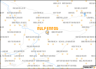
Rülfenrod (Hessen, Germany)Rülfenrod is a town in the Hessen region of Germany. An overview map of the region around Rülfenrod is displayed below.
regional and 3d topo map of Rülfenrod, Germany ::
Rülfenrod airports ::
The nearest airport is ZNF - Hanau Aaf, located 59.7 km south of Rülfenrod.
Other airports nearby include KSF - Kassel Calden (81.5 km north), FRA - Frankfurt Main (84.2 km south west), PAD - Paderborn Lippstadt (106.8 km north), ZNV - Koblenz Winningen (117.9 km west), Nearby towns ::
Otterbach (1.9km south) //
Elpenrod (3.7km south) //
Oberndorf (2.3km east) //
Ehringshausen (2.3km east) //
Niedergemünden (3.0km south west) //
Hainbach (3.9km south) //
Maulbach (4.4km north west) //
Erbenhausen (5.7km north) //
Burg Gemünden (4.0km south west) //
Appenrod (6.0km north west) //
Ermenrod (5.1km south east) //
Bleidenrod (5.0km west) //
Wettsaasen (7.5km south) //
Ober-Gleen (6.6km north east) //
Nieder Ohmen (6.6km south west) //
Lehrbach (7.8km north) //
Schellnhausen (6.0km south east) //
Kirschgarten (7.8km south) //
Kirtorf (7.8km north) //
Dannenrod (7.3km north west) //
Ober Ohmen (8.2km south east) //
Klein Felda (8.8km south east) //
Zeilbach (8.8km south east) //
[all distances 'as the bird flies' and approximate]  Places with similar names to Rülfenrod, Germany :: Disclaimer :: Information on this page comes without warranty of any kind |
||
|
Where is Rülfenrod? Elevation and coordinates ::
Latitude (lat): 50°42'0"N Longitude (lon): 9°5'0"E
Elevation (approx.): 248m (map arrows pan, magnifying glasses zoom) |
||
|
Visiting Rülfenrod? Hotel/Accommodation ::
Book a hotel in Rülfenrod Travel Guide ::
Buy a travel guide for Germany rental cars ::
car rental offers GPS waypoint ::
download a GPX waypoint (PoI) of Rülfenrod for your GPS receiver
|
||