|
search place name
|
||
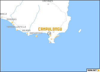
Campu Longu (Sardegna, Italy)Campu Longu is a town in the Sardegna region of Italy. An overview map of the region around Campu Longu is displayed below.
regional and 3d topo map of Campu Longu, Italy ::
Campu Longu airports ::
The nearest airport is CAG - Cagliari Elmas, located 41.4 km west of Campu Longu.
Other airports nearby include DCI - Decimomannu (52.5 km north west), TTB - Tortoli (89.1 km north), OLB - Olbia Costa Smeralda (196.6 km north), AHO - Alghero (196.7 km north west), Nearby towns ::
Oasi dei Due Mari (0.1km north east) //
Notteri (1.1km south) //
Serrʼe Morus (1.6km south east) //
Tanka Village (1.6km east) //
Villasimìus (1.9km north east) //
San Stèfano (2.3km south) //
Simius (2.1km east) //
Is Traias (2.5km east) //
Portu sa Ruxi (3.9km west) //
Solànas (6.8km west) //
[all distances 'as the bird flies' and approximate] 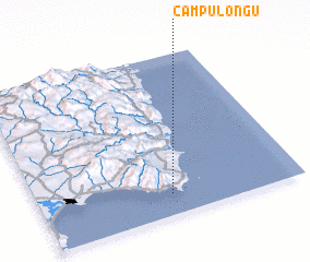 Places with similar names to Campu Longu, Italy ::
// Campalingo (PH)
// Kimpling (AT)
// Campolungo (IT)
// Camplengo (ES)
// Camplongo (ES)
// Campolongo (ES)
// Camp Long (US)
// Kimpalanga (CG)
// Camplong (ID)
// Kemplang (ID)
Disclaimer :: Information on this page comes without warranty of any kind |
||
|
Where is Campu Longu? Elevation and coordinates ::
Latitude (lat): 39°7'42"N Longitude (lon): 9°30'24"E
Elevation (approx.): 6m (map arrows pan, magnifying glasses zoom) |
||
|
Visiting Campu Longu? Hotel/Accommodation ::
Book a hotel in Campu Longu Travel Guide ::
Buy a travel guide for Italy rental cars ::
car rental offers GPS waypoint ::
download a GPX waypoint (PoI) of Campu Longu for your GPS receiver
|
||