|
search place name
|
||
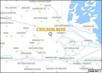
Conca dʼAlbero (Veneto, Italy)Conca dʼAlbero is a town in the Veneto region of Italy. An overview map of the region around Conca dʼAlbero is displayed below.
regional and 3d topo map of Conca dʼAlbero, Italy ::
Conca dʼAlbero airports ::
The nearest airport is QPA - Padova, located 27.1 km north west of Conca dʼAlbero.
Other airports nearby include VCE - Venice Venezia Tessera (38.6 km north east), TSF - Treviso (48.9 km north), VIC - Vicenza (58.7 km north west), VRN - Villafranca (95.6 km west), Nearby towns ::
Cantarana (2.5km south east) //
Correzzola (2.5km north west) //
Tre Ponti (2.8km east) //
Pegolotte (4.1km south west) //
Santa Margherita (4.4km north east) //
Boaria Solferino (5.6km south) //
Codevigo (6.1km north) //
Villa del Bosco (4.5km west) //
Arzergrande (6.2km north west) //
Pontelongo (5.8km north west) //
Macchina Tassi (6.6km south west) //
Cona (5.9km south west) //
Coette (7.5km south) //
Sista (6.4km south east) //
Cavarzere (8.9km south) //
Motta Amolara (7.7km south east) //
Rottanova (9.8km south west) //
[all distances 'as the bird flies' and approximate] 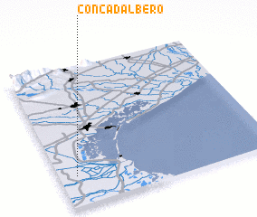 Places with similar names to Conca dʼAlbero, Italy :: Disclaimer :: Information on this page comes without warranty of any kind |
||
|
Where is Conca dʼAlbero? Elevation and coordinates ::
Latitude (lat): 45°12'56"N Longitude (lon): 12°4'50"E
Elevation (approx.): 1m (map arrows pan, magnifying glasses zoom) |
||
|
Visiting Conca dʼAlbero? Hotel/Accommodation ::
Book a hotel in Conca dʼAlbero Travel Guide ::
Buy a travel guide for Italy rental cars ::
car rental offers GPS waypoint ::
download a GPX waypoint (PoI) of Conca dʼAlbero for your GPS receiver
|
||