|
search place name
|
||
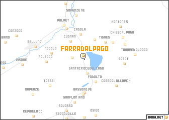
Farra dʼAlpago (Veneto, Italy)Farra dʼAlpago is a town in the Veneto region of Italy. An overview map of the region around Farra dʼAlpago is displayed below.
regional and 3d topo map of Farra dʼAlpago, Italy ::
Farra dʼAlpago airports ::
The nearest airport is AVB - Aviano Ab (Pagliano E Gori), located 23.5 km south east of Farra dʼAlpago.
Other airports nearby include TSF - Treviso (53.1 km south), VCE - Venice Venezia Tessera (68.2 km south), BZO - Bolzano (85.4 km north west), VIC - Vicenza (86.2 km south west), Nearby towns ::
Quantin (2.0km west) //
Santa Croce del Lago (2.9km south) //
Pieve dʼAlpago (4.8km north) //
Cugnan (4.7km north west) //
Fadalto (5.2km south) //
Puos dʼAlpago (4.4km north east) //
Cadola (5.7km north) //
Tignes (5.1km north east) //
Alto Nove (7.3km south) //
Modolo (5.3km west) //
Garna dʼAlpago (5.9km north east) //
Basso Nove (7.6km south) //
Ponte nellʼAlpi (7.5km north) //
Faverga (5.9km west) //
Spert (6.2km east) //
Polpet (8.4km north) //
Casera Vallorch (7.6km south east) //
Tassei (7.8km south west) //
Chies dʼAlpago (7.8km north east) //
Montanes (9.2km north east) //
[all distances 'as the bird flies' and approximate]  Places with similar names to Farra dʼAlpago, Italy :: Disclaimer :: Information on this page comes without warranty of any kind |
||
|
Where is Farra dʼAlpago? Elevation and coordinates ::
Latitude (lat): 46°7'6"N Longitude (lon): 12°19'9"E
Elevation (approx.): 553m (map arrows pan, magnifying glasses zoom) |
||
|
Visiting Farra dʼAlpago? Hotel/Accommodation ::
Book a hotel in Farra dʼAlpago Travel Guide ::
Buy a travel guide for Italy rental cars ::
car rental offers GPS waypoint ::
download a GPX waypoint (PoI) of Farra dʼAlpago for your GPS receiver
|
||