|
search place name
|
||
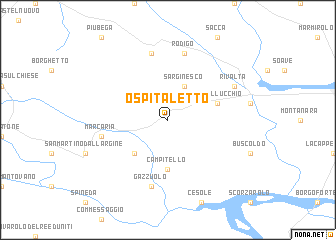
Ospitaletto (Italy)Ospitaletto is a town in Italy. An overview map of the region around Ospitaletto is displayed below.
regional and 3d topo map of Ospitaletto, Italy ::
Ospitaletto airports ::
The nearest airport is VRN - Villafranca, located 36.9 km north east of Ospitaletto.
Other airports nearby include VBS - Montichiari (39.1 km north west), PMF - Parma (41.9 km south west), QPZ - Piacenza (73.3 km west), BLQ - Bologna (85.9 km south east), Nearby towns ::
Sarginesco (3.9km north) //
San Michele in Bosco (4.5km south west) //
Campitello (5.6km south) //
Castellucchio (4.3km north east) //
Gazzuolo (7.5km south) //
Marcaria (5.5km west) //
Gazoldo degli Ippoliti (7.5km north) //
Rodigo (7.5km north) //
Rivalta (6.4km north east) //
[all distances 'as the bird flies' and approximate] 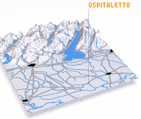 Places with similar names to Ospitaletto, Italy ::
// Ospedaletto (IT)
// Ospedaletto (IT)
// Ospedaletto (IT)
// Ospedaletto (IT)
// Ospedaletto (IT)
// Ospitaletto (IT)
// Ospitaletto (IT)
// Ospedaletti (IT)
// Ospitaletto (IT)
// Ospedaletto (IT)
Disclaimer :: Information on this page comes without warranty of any kind |
||
|
Where is Ospitaletto? Elevation and coordinates ::
Latitude (lat): 45°8'0"N Longitude (lon): 10°36'0"E
Elevation (approx.): 24m (map arrows pan, magnifying glasses zoom) |
||
|
Visiting Ospitaletto? Hotel/Accommodation ::
Book a hotel in Ospitaletto Travel Guide ::
Buy a travel guide for Italy rental cars ::
car rental offers GPS waypoint ::
download a GPX waypoint (PoI) of Ospitaletto for your GPS receiver
|
||