|
search place name
|
||
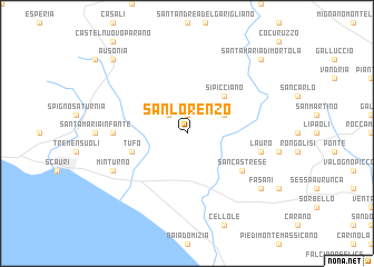
San Lorenzo (Italy)San Lorenzo is a town in Italy. An overview map of the region around San Lorenzo is displayed below.
regional and 3d topo map of San Lorenzo, Italy ::
San Lorenzo airports ::
The nearest airport is NAP - Naples Capodichino, located 59.4 km south east of San Lorenzo.
Other airports nearby include QLT - Latina (81.2 km west), CIA - Rome Ciampino (116.9 km north west), PSR - Pescara (131.1 km north), FCO - Rome Fiumicino (142.9 km north west), Nearby towns ::
Castelforte (1.9km north) //
Santi Cosma e Damiano (2.3km north west) //
Ventosa (2.3km north west) //
Suio (3.3km north east) //
Sipicciano (4.6km north east) //
Tufo (4.6km south west) //
San Castrese (5.6km south east) //
Pulcherini (5.6km west) //
Lauro (5.9km east) //
Minturno (6.7km south west) //
Fasani (7.9km south east) //
Santa Maria di Mortola (9.3km north east) //
Ausonia (9.3km north west) //
[all distances 'as the bird flies' and approximate]  Places with similar names to San Lorenzo, Italy ::
// San Lorenzo (BZ)
// San Lorenzo (US)
// San Lorenzo (PA)
// San Lorenzo (IT)
// San Lorenzo (IT)
// San Lorenzo (IT)
// San Lorenzo (IT)
// San Lorenzo (IT)
// San Lorenzo (IT)
// San Lorenzo (IT)
Disclaimer :: Information on this page comes without warranty of any kind |
||
|
Where is San Lorenzo? Elevation and coordinates ::
Latitude (lat): 41°17'0"N Longitude (lon): 13°49'0"E
Elevation (approx.): 23m (map arrows pan, magnifying glasses zoom) |
||
|
Visiting San Lorenzo? Hotel/Accommodation ::
Book a hotel in San Lorenzo Travel Guide ::
Buy a travel guide for Italy rental cars ::
car rental offers GPS waypoint ::
download a GPX waypoint (PoI) of San Lorenzo for your GPS receiver
|
||