|
search place name
|
||
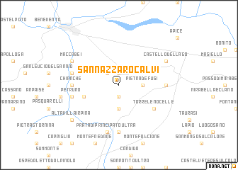
San Nazzaro Calvi (Italy)San Nazzaro Calvi is a town in Italy. An overview map of the region around San Nazzaro Calvi is displayed below.
regional and 3d topo map of San Nazzaro Calvi, Italy ::
San Nazzaro Calvi airports ::
The nearest airport is NAP - Naples Capodichino, located 50.5 km west of San Nazzaro Calvi.
Other airports nearby include FOG - Foggia Gino Lisa (71.5 km north east), BRI - Bari (160.8 km east), PSR - Pescara (163.2 km north), QLT - Latina (171.5 km west), Nearby towns ::
Montefusco (1.9km south) //
San Giorgio del Sannio (1.9km north) //
San Martino Sannita (2.3km north west) //
Santa Paolina (3.7km south) //
Pietradefusi (2.8km east) //
Torrioni (4.6km south west) //
Torre le Nocelle (5.6km south east) //
Montemiletto (5.6km south east) //
Bagnara (5.6km west) //
Pratola Serra (7.4km south) //
Chianche (5.6km west) //
Campanarello (5.6km east) //
Petruro (5.9km west) //
Prata di Principato Ultra (7.5km south) //
Pagliara (5.9km west) //
Maccabei (6.7km north west) //
Castello del Lago (6.7km north east) //
Altavilla Irpina (7.9km south west) //
[all distances 'as the bird flies' and approximate]  Places with similar names to San Nazzaro Calvi, Italy :: Disclaimer :: Information on this page comes without warranty of any kind |
||
|
Where is San Nazzaro Calvi? Elevation and coordinates ::
Latitude (lat): 41°3'0"N Longitude (lon): 14°51'0"E
Elevation (approx.): 436m (map arrows pan, magnifying glasses zoom) |
||
|
Visiting San Nazzaro Calvi? Hotel/Accommodation ::
Book a hotel in San Nazzaro Calvi Travel Guide ::
Buy a travel guide for Italy rental cars ::
car rental offers GPS waypoint ::
download a GPX waypoint (PoI) of San Nazzaro Calvi for your GPS receiver
|
||