|
search place name
|
||
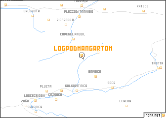
Log pod Mangartom (Cankova-Tišina, Slovenia)Log pod Mangartom is a town in the Cankova-Tišina region of Slovenia. An overview map of the region around Log pod Mangartom is displayed below.
regional and 3d topo map of Log pod Mangartom, Slovenia ::
Log pod Mangartom airports ::
The nearest airport is KLU - Klagenfurt (Worthersee Intl), located 62.8 km north east of Log pod Mangartom.
Other airports nearby include TRS - Ronchi De Legionari Ronchi Dei Legionari (64.6 km south), LJU - Ljubliana Ljubljana (69.2 km east), AVB - Aviano Ab (Pagliano E Gori) (87.5 km south west), POW - Portoroz (103.2 km south), Nearby towns ::
Strmec na Predelu (2.8km north east) //
Bavšica (4.4km south east) //
Cave del Predil (4.8km north) //
Kal-Koritnica (7.2km south) //
Bovec (7.9km south west) //
Riofreddo (8.2km north) //
Soča (8.0km south east) //
Plužna (9.2km south west) //
Montesanto di Lussari (10.3km north west) //
[all distances 'as the bird flies' and approximate] 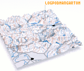 Places with similar names to Log pod Mangartom, Slovenia :: Disclaimer :: Information on this page comes without warranty of any kind |
||
|
Where is Log pod Mangartom? Elevation and coordinates ::
Latitude (lat): 46°24'7"N Longitude (lon): 13°35'49"E
Elevation (approx.): 619m (map arrows pan, magnifying glasses zoom) |
||
|
Visiting Log pod Mangartom? Hotel/Accommodation ::
Book a hotel in Log pod Mangartom Travel Guide ::
Buy a travel guide for Slovenia rental cars ::
car rental offers GPS waypoint ::
download a GPX waypoint (PoI) of Log pod Mangartom for your GPS receiver
|
||