|
search place name
|
||
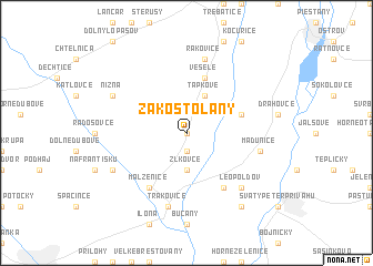
Zákostolany (Slovakia)Zákostolany is a town in Slovakia. An overview map of the region around Zákostolany is displayed below.
regional and 3d topo map of Zákostolany, Slovakia ::
Zákostolany airports ::
The nearest airport is PZY - Piestany, located 16.2 km north east of Zákostolany.
Other airports nearby include BTS - Bratislava M R Stefanik (52.4 km south west), VIE - Vienna Schwechat (95.5 km south west), BRQ - Turany (104.3 km north west), PRV - Prerov (105.5 km north), Nearby towns ::
Veľké Kostoľany (0.0km north) //
Pečeňady (1.9km south) //
Žlkovce (3.7km south) //
Ratkovce (3.7km south) //
ťapkové (3.9km north) //
Dubovany (3.9km north) //
Veselé (5.7km north) //
Dolné Voderady (4.1km north east) //
Červeník (6.1km south east) //
Malženice (6.1km south west) //
Madunice (5.3km east) //
Rakovice (7.5km north) //
Trakovice (7.5km south) //
Leopoldov (6.7km south east) //
Jaslovce (6.2km south west) //
Nižná (6.2km north west) //
Bohunice (6.2km south west) //
Jaslovské Bohunice (6.2km south west) //
Šulekovo (8.3km south east) //
[all distances 'as the bird flies' and approximate] 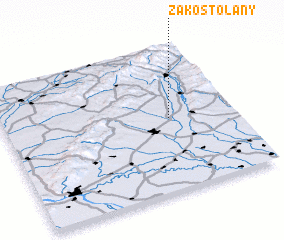 Places with similar names to Zákostolany, Slovakia ::
// Saxdalen (SE)
Disclaimer :: Information on this page comes without warranty of any kind |
||
|
Where is Zákostolany? Elevation and coordinates ::
Latitude (lat): 48°30'0"N Longitude (lon): 17°43'0"E
Elevation (approx.): 161m (map arrows pan, magnifying glasses zoom) |
||
|
Visiting Zákostolany? Hotel/Accommodation ::
Book a hotel in Zákostolany Travel Guide ::
Buy a travel guide for Slovakia rental cars ::
car rental offers GPS waypoint ::
download a GPX waypoint (PoI) of Zákostolany for your GPS receiver
|
||