|
search place name
|
||
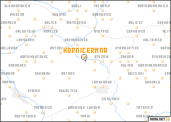
Horní Čermná (Czech Republic)Horní Čermná is a town in Czech Republic. An overview map of the region around Horní Čermná is displayed below.
regional and 3d topo map of Horní Čermná, Czech Republic ::
Horní Čermná airports ::
The nearest airport is PED - Pardubice, located 60.8 km west of Horní Čermná.
Other airports nearby include PRV - Prerov (84.4 km south east), BRQ - Turany (91.0 km south), OSR - Ostrava Mosnov (114.0 km east), WRO - Wroclaw Strachowice (128.2 km north), Nearby towns ::
Čermná (1.9km north) //
Dolní Čermná (1.9km north) //
Marianská Hora (1.2km east) //
Horní Třešňovec (2.2km south east) //
Stežník (2.4km east) //
Verměřovice (3.9km north) //
Ostrov (4.4km south west) //
Nepomuky (3.6km east) //
Petrovice (4.0km north west) //
Dolní Třešňovec (5.7km south) //
Lanškroun (6.1km south east) //
Bystřec (6.0km north east) //
Horní Dobrouč (4.8km west) //
Halda (4.8km east) //
Mistrovice (7.5km north) //
Jablonné nad Orlicí (7.5km north) //
Sázava (5.1km east) //
Rudoltice (7.8km south) //
Albrechtice (6.0km south east) //
Kunčice (7.3km north west) //
Orlice (8.8km north west) //
[all distances 'as the bird flies' and approximate]  Places with similar names to Horní Čermná, Czech Republic :: Disclaimer :: Information on this page comes without warranty of any kind |
||
|
Where is Horní Čermná? Elevation and coordinates ::
Latitude (lat): 49°58'0"N Longitude (lon): 16°35'0"E
Elevation (approx.): 448m (map arrows pan, magnifying glasses zoom) |
||
|
Visiting Horní Čermná? Hotel/Accommodation ::
Book a hotel in Horní Čermná Travel Guide ::
rental cars ::
car rental offers GPS waypoint ::
download a GPX waypoint (PoI) of Horní Čermná for your GPS receiver
|
||