|
search place name
|
||
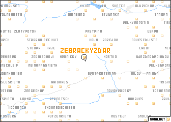
Žebrácký Žďár (Czech Republic)Žebrácký Žďár is a town in Czech Republic. An overview map of the region around Žebrácký Žďár is displayed below.
regional and 3d topo map of Žebrácký Žďár, Czech Republic ::
Žebrácký Žďár airports ::
The nearest airport is KLV - Karlovy Vary, located 61.8 km north east of Žebrácký Žďár.
Other airports nearby include BYU - Bayreuth (72.8 km north west), HOQ - Hof Plauen (82.3 km north west), NUE - Nuernberg Nurnberg (109.5 km west), PRG - Prague Ruzyne (130.7 km east), Nearby towns ::
Nové Domky (2.2km south west) //
Hraničky (2.4km west) //
Polesí (3.7km south) //
Rozvadov (3.7km south) //
Kolm (3.9km north) //
Žebráky (3.0km north east) //
Reichenau (3.0km south west) //
Svatá Kateřina (4.4km south east) //
Lesná (5.6km north) //
Hošťka (3.6km east) //
Bažantov (5.7km north) //
Pastvina (5.7km north) //
Pořejov (5.2km north east) //
Pfälzerhof (6.1km south west) //
Háje (5.1km west) //
Frankenreuth (6.6km south west) //
Waidhaus (6.6km south west) //
Milíře (6.1km south east) //
Diana (7.8km south) //
Ödkührieth (7.3km south west) //
Novohradský (8.8km south east) //
[all distances 'as the bird flies' and approximate]  Places with similar names to Žebrácký Žďár, Czech Republic :: Disclaimer :: Information on this page comes without warranty of any kind |
||
|
Where is Žebrácký Žďár? Elevation and coordinates ::
Latitude (lat): 49°42'0"N Longitude (lon): 12°33'0"E
Elevation (approx.): 613m (map arrows pan, magnifying glasses zoom) |
||
|
Visiting Žebrácký Žďár? Hotel/Accommodation ::
Book a hotel in Žebrácký Žďár Travel Guide ::
rental cars ::
car rental offers GPS waypoint ::
download a GPX waypoint (PoI) of Žebrácký Žďár for your GPS receiver
|
||