|
search place name
|
||
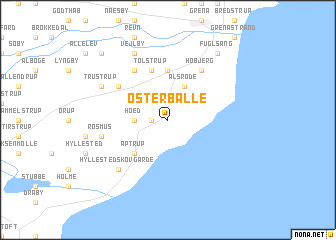
Østerballe (Århus, Denmark)Østerballe is a town in the Århus region of Denmark. An overview map of the region around Østerballe is displayed below.
regional and 3d topo map of Østerballe, Denmark ::
Østerballe airports ::
The nearest airport is AAR - Aarhus, located 14.4 km west of Østerballe.
Other airports nearby include ODE - Odense (99.0 km south), AAL - Aalborg (106.0 km north west), KRP - Karup (106.8 km west), RKE - Copenhagen Roskilde (114.2 km south east), Nearby towns ::
Glatved (1.0km west) //
Balle (2.1km west) //
Hoed (2.1km west) //
Ålsrode (3.8km north) //
Aptrup (4.2km south west) //
Ålsø (5.6km north) //
Tolstrup (5.7km north) //
Lund (4.8km north west) //
Homå (5.9km north) //
Høbjerg (5.9km north) //
Rosmus (4.5km south west) //
Hyllested Skovgårde (6.4km south west) //
Vejlby (7.7km north) //
Trustrup (5.5km north west) //
Fuglsang (8.0km north east) //
Fladstrup (8.5km north west) //
[all distances 'as the bird flies' and approximate] 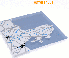 Places with similar names to Østerballe, Denmark ::
Disclaimer :: Information on this page comes without warranty of any kind |
||
|
Where is Østerballe? Elevation and coordinates ::
Latitude (lat): 56°19'0"N Longitude (lon): 10°51'0"E
Elevation (approx.): 23m (map arrows pan, magnifying glasses zoom) |
||
|
Visiting Østerballe? Hotel/Accommodation ::
Book a hotel in Østerballe Travel Guide ::
Buy a travel guide for Denmark rental cars ::
car rental offers GPS waypoint ::
download a GPX waypoint (PoI) of Østerballe for your GPS receiver
|
||