|
search place name
|
||
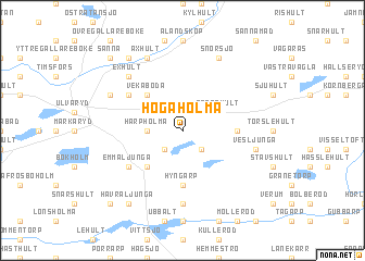
Högaholma (Kronoberg, Sweden)Högaholma is a town in the Kronoberg region of Sweden. An overview map of the region around Högaholma is displayed below.
regional and 3d topo map of Högaholma, Sweden ::
Högaholma airports ::
The nearest airport is HAD - Halmstad, located 61.2 km north west of Högaholma.
Other airports nearby include KID - Kristianstad (61.8 km south east), JLD - Landskrona (75.0 km south west), VXO - Vaxjo Kronoberg (83.8 km north east), RNB - Ronneby (98.5 km east), Nearby towns ::
Boalt (2.1km south east) //
Bröna (2.1km south west) //
Grysshult (2.1km north east) //
Harpholma (2.0km west) //
Göshult (2.8km north west) //
Stenshult (2.8km north east) //
Björstorp (4.2km south west) //
Vekaboda (4.2km north west) //
Applehult (3.1km east) //
Hyngarp (5.6km south) //
Emmaljunga (4.8km south west) //
Fjärholma (4.8km north west) //
Gundrastorp (7.4km south) //
Vesljunga (4.5km south east) //
Exhult (6.4km north west) //
Axhult (7.7km north) //
Snörsjö (7.7km north) //
Misterhult (5.5km north west) //
Havraljunga (8.0km south west) //
Åsa (8.0km north) //
Oretorp (8.5km south west) //
Sånna (8.5km north west) //
[all distances 'as the bird flies' and approximate]  Places with similar names to Högaholma, Sweden ::
// Högaholma (SE)
Disclaimer :: Information on this page comes without warranty of any kind |
||
|
Where is Högaholma? Elevation and coordinates ::
Latitude (lat): 56°26'0"N Longitude (lon): 13°42'0"E
Elevation (approx.): 137m (map arrows pan, magnifying glasses zoom) |
||
|
Visiting Högaholma? Hotel/Accommodation ::
Book a hotel in Högaholma Travel Guide ::
Buy a travel guide for Sweden rental cars ::
car rental offers GPS waypoint ::
download a GPX waypoint (PoI) of Högaholma for your GPS receiver
|
||