|
search place name
|
||
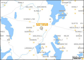
Sötåsa (Jönköping, Sweden)Sötåsa is a town in the Jönköping region of Sweden. An overview map of the region around Sötåsa is displayed below.
regional and 3d topo map of Sötåsa, Sweden ::
Sötåsa airports ::
The nearest airport is VXO - Vaxjo Kronoberg, located 37.1 km south east of Sötåsa.
Other airports nearby include JKG - Joenkoeping Jonkoping (67.3 km north), HLF - Hultsfred (100.1 km north east), HAD - Halmstad (104.5 km south west), RNB - Ronneby (116.3 km south east), Nearby towns ::
Gölsebo (1.0km west) //
Gunnamo (1.0km east) //
Älgaryd (2.7km north west) //
Ugglekull (3.8km south) //
Os (4.2km north east) //
Gimmarp (3.0km west) //
Ramnås (3.0km west) //
Björnhult (3.5km south west) //
Ekeberg (5.9km south) //
Stora Hyltan (4.8km north west) //
Risbygd (4.8km south west) //
Skaverås (4.8km south west) //
Tuddabo (7.4km south) //
Älmhult (7.5km north) //
Hult (7.5km south) //
Lyåsa (5.5km south east) //
Strömhult (6.9km south east) //
[all distances 'as the bird flies' and approximate]  Places with similar names to Sötåsa, Sweden ::
// Sadies (MA)
// Sidi Aïssa (MA)
// Sidi Aïssa (MA)
// Sidi Aïssa (MA)
// Sidi Aïssa (MA)
// Sidi Aïssa (MA)
// Seytas (AZ)
// Satsa (MM)
// Satse (MM)
// Setzaw (MM)
Disclaimer :: Information on this page comes without warranty of any kind |
||
|
Where is Sötåsa? Elevation and coordinates ::
Latitude (lat): 57°10'0"N Longitude (lon): 14°18'0"E
Elevation (approx.): 215m (map arrows pan, magnifying glasses zoom) |
||
|
Visiting Sötåsa? Hotel/Accommodation ::
Book a hotel in Sötåsa Travel Guide ::
Buy a travel guide for Sweden rental cars ::
car rental offers GPS waypoint ::
download a GPX waypoint (PoI) of Sötåsa for your GPS receiver
|
||