|
search place name
|
||
Säynejärvi (Itä-Suomen Lääni, Finland)Säynejärvi is a town in the Itä-Suomen Lääni region of Finland. An overview map of the region around Säynejärvi is displayed below.
regional and 3d topo map of Säynejärvi, Finland ::

Säynejärvi airports ::
The nearest airport is SVL - Savonlinna, located 68.6 km west of Säynejärvi.
Other airports nearby include JOE - Joensuu (82.7 km north west), Nearby towns ::
Satulavaara (0.9km east) //
Tiekoski (1.9km north) //
Hantta (3.8km south) //
Kattilavaara (3.2km north east) //
Lahdenkylä (4.5km south east) //
Niinimäki (7.4km south) //
Salokylä (6.1km north east) //
Riihijärvi (5.1km south west) //
Kiteenlahti (7.6km north) //
Multamäki (7.6km north) //
Loukunvaara (6.6km north west) //
[all distances 'as the bird flies' and approximate] 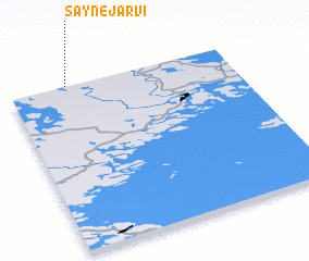 Places with similar names to Säynejärvi, Finland ::
// Snegirevo (KZ)
// Säänjärvi (FI)
// Saunajärvi (FI)
// Säynäjärvi (FI)
// Snegirëvo (RU)
// Snegirëvo (RU)
// Snigerëva (RU)
// Snigirëvo (RU)
Disclaimer :: Information on this page comes without warranty of any kind |
||
|
Where is Säynejärvi? Elevation and coordinates ::
Latitude (lat): 61°59'0"N Longitude (lon): 30°15'0"E
(map arrows pan, magnifying glasses zoom) |
||
|
Visiting Säynejärvi? Hotel/Accommodation ::
Book a hotel in Säynejärvi Travel Guide ::
Buy a travel guide for Finland rental cars ::
car rental offers GPS waypoint ::
download a GPX waypoint (PoI) of Säynejärvi for your GPS receiver
|
||