|
search place name
|
||
(( Vodenjak )) (Primorsko-Goranska Županija, Croatia)(( Vodenjak )) is a town in the Primorsko-Goranska Županija region of Croatia. An overview map of the region around (( Vodenjak )) is displayed below.
regional and 3d topo map of (( Vodenjak )), Croatia ::

(( Vodenjak )) airports ::
The nearest airport is RJK - Rijeka, located 28.7 km south west of (( Vodenjak )).
Other airports nearby include PUY - Pula (90.9 km south west), POW - Portoroz (96.0 km west), LJU - Ljubliana Ljubljana (96.8 km north), ZAG - Zagreb (103.7 km east), Nearby towns ::
Marija Trošt (3.0km north west) //
Zalesina (2.8km south east) //
Delnice (3.0km west) //
Lučice (3.8km south west) //
Kupjak (3.9km east) //
Poljička Kosa (5.8km south) //
Mala Lešnica (6.3km north) //
Stari Laz (5.2km south east) //
Brod na Kupi (7.2km north) //
Sije (5.6km east) //
Sunger (8.0km south) //
Guče Selo (8.0km north) //
(( Skendri )) (8.5km north) //
Mrkopalj (8.8km south) //
Skrad (6.9km north east) //
Brestova Draga (8.8km south) //
Kuželj (9.2km north) //
Donja Slavica (9.3km south west) //
[all distances 'as the bird flies' and approximate] 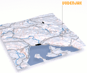 Places with similar names to (( Vodenjak )), Croatia ::
// Vodenjak (HR)
Disclaimer :: Information on this page comes without warranty of any kind |
||
|
Where is (( Vodenjak ))? Elevation and coordinates ::
Latitude (lat): 45°23'38"N Longitude (lon): 14°50'11"E
Elevation (approx.): 808m (map arrows pan, magnifying glasses zoom) |
||
|
Visiting (( Vodenjak ))? Hotel/Accommodation ::
Book a hotel in (( Vodenjak )) Travel Guide ::
Buy a travel guide for Croatia rental cars ::
car rental offers GPS waypoint ::
download a GPX waypoint (PoI) of (( Vodenjak )) for your GPS receiver
|
||