|
search place name
|
||
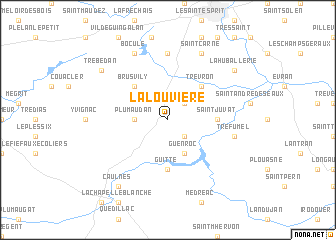
La Louvière (Bretagne, France)La Louvière is a town in the Bretagne region of France. An overview map of the region around La Louvière is displayed below.
regional and 3d topo map of La Louvière, France ::
La Louvière airports ::
The nearest airport is DNR - Dinard Pleurtuit, located 26.5 km north of La Louvière.
Other airports nearby include RNS - Rennes St Jacques (41.3 km south east), SBK - St.-brieuc Armor Armor (59.6 km west), VNE - Vannes Meucon (83.6 km south west), JER - Jersey (95.7 km north), Nearby towns ::
La Rehaudais (2.2km south east) //
Saint-Maden (2.2km south east) //
La Gaudière (2.2km north east) //
Plumaudan (2.5km west) //
Guenroc (3.9km south) //
Brusvily (4.5km north west) //
Trévron (4.5km north east) //
Le Hinglé (4.5km north east) //
Saint-Juvat (3.7km east) //
Guitté (5.6km south) //
Bobital (7.4km north) //
Tréfumel (5.3km east) //
Boculé (7.8km north) //
Saint-Carné (7.8km north) //
Trébédan (7.4km north west) //
La Huballerie (7.4km north east) //
Caulnes (8.3km south west) //
[all distances 'as the bird flies' and approximate] 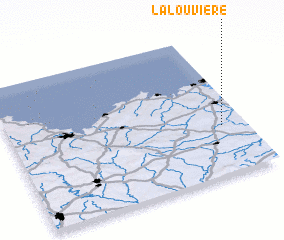 Places with similar names to La Louvière, France ::
Disclaimer :: Information on this page comes without warranty of any kind |
||
|
Where is La Louvière? Elevation and coordinates ::
Latitude (lat): 48°21'0"N Longitude (lon): 2°6'0"W
Elevation (approx.): 50m (map arrows pan, magnifying glasses zoom) |
||
|
Visiting La Louvière? Hotel/Accommodation ::
Book a hotel in La Louvière Travel Guide ::
Buy a travel guide for France rental cars ::
car rental offers GPS waypoint ::
download a GPX waypoint (PoI) of La Louvière for your GPS receiver
|
||