|
search place name
|
||
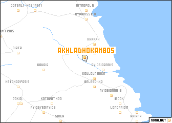
Akhladhókambos (Piraiévs, Greece)Akhladhókambos is a town in the Piraiévs region of Greece. An overview map of the region around Akhladhókambos is displayed below.
regional and 3d topo map of Akhladhókambos, Greece ::
Akhladhókambos airports ::
The nearest airport is KIT - Kithira, located 67.7 km south of Akhladhókambos.
Other airports nearby include KLX - Kalamata (87.7 km west), CHQ - Chania Souda (183.0 km south east), PYR - Andravida (188.8 km north west), GPA - Patras Araxos (196.9 km north west), Nearby towns ::
Lambókambos (2.4km north west) //
Pistámata (2.4km north east) //
Paraskaíika (4.0km south) //
Rikhéa (4.0km south) //
Spithaíika (4.0km south) //
Koulouraíika (4.0km south) //
Áyios Ioánnis (3.5km south east) //
Khárax (4.0km north) //
Belesaíika (5.8km south) //
Áyios Ioánnis (8.6km south east) //
[all distances 'as the bird flies' and approximate] 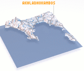 Places with similar names to Akhladhókambos, Greece ::
// Akhladhókambos (GR)
Disclaimer :: Information on this page comes without warranty of any kind |
||
|
Where is Akhladhókambos? Elevation and coordinates ::
Latitude (lat): 36°53'0"N Longitude (lon): 22°59'0"E
Elevation (approx.): 457m (map arrows pan, magnifying glasses zoom) |
||
|
Visiting Akhladhókambos? Hotel/Accommodation ::
Book a hotel in Akhladhókambos Travel Guide ::
Buy a travel guide for Greece rental cars ::
car rental offers GPS waypoint ::
download a GPX waypoint (PoI) of Akhladhókambos for your GPS receiver
|
||