|
search place name
|
||
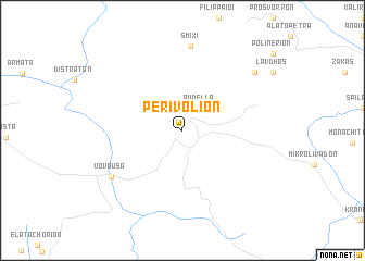
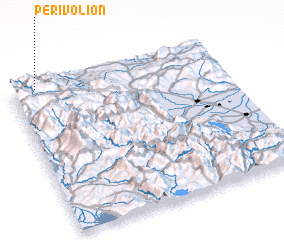
Perivólion (Grevená, Greece)Perivólion is a town in the Grevená region of Greece. An overview map of the region around Perivólion is displayed below.
regional and 3d topo map of Perivólion, Greece ::
Perivólion airports ::
The nearest airport is IOA - Ioannina, located 40.3 km south west of Perivólion.
Other airports nearby include KSO - Kastoria Aristotelis (53.7 km north), KZI - Kozani Filippos (70.5 km north east), CFU - Kerkyra/corfu Ioannis Kapodistrias Intl (111.4 km west), PVK - Preveza Aktio (120.9 km south), Nearby towns ::
 Places with similar names to Perivólion, Greece ::
// Perivólion (GR)
// Perivólion (GR)
// Perivólion (GR)
// Perivólion (GR)
// Perivólion (GR)
// Prevelianá (GR)
// Prăvăleni (RO)
// Pereval'nyy (RU)
// Pereval'nyy (RU)
// Prīvol'noe (KZ)
Disclaimer :: Information on this page comes without warranty of any kind |
||
|
Where is Perivólion? Elevation and coordinates ::
Latitude (lat): 39°58'46"N Longitude (lon): 21°6'59"E
Elevation (approx.): 1258m (map arrows pan, magnifying glasses zoom) |
||
|
Visiting Perivólion? Hotel/Accommodation ::
Book a hotel in Perivólion Travel Guide ::
Buy a travel guide for Greece rental cars ::
car rental offers GPS waypoint ::
download a GPX waypoint (PoI) of Perivólion for your GPS receiver
|
||