|
search place name
|
||
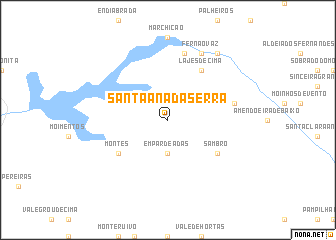
Santa Ana da Serra (Beja, Portugal)Santa Ana da Serra is a town in the Beja region of Portugal. An overview map of the region around Santa Ana da Serra is displayed below.
regional and 3d topo map of Santa Ana da Serra, Portugal ::
Santa Ana da Serra airports ::
The nearest airport is FAO - Faro, located 61.5 km south east of Santa Ana da Serra.
Other airports nearby include LIS - Lisbon Lisboa (160.0 km north west), BJZ - Badajoz Talavera La Real (201.6 km north east), Nearby towns ::
Empardeadas (3.7km south) //
Lajes de Cima (6.3km north east) //
Montes (5.8km south west) //
Sambro (5.8km south east) //
Alcaria (7.6km north) //
Monte das Figueiras (6.2km east) //
Fernão Vaz (8.0km north) //
Arreganhado (8.6km north east) //
[all distances 'as the bird flies' and approximate]  Places with similar names to Santa Ana da Serra, Portugal :: Disclaimer :: Information on this page comes without warranty of any kind |
||
|
Where is Santa Ana da Serra? Elevation and coordinates ::
Latitude (lat): 37°30'0"N Longitude (lon): 8°18'0"W
Elevation (approx.): 181m (map arrows pan, magnifying glasses zoom) |
||
|
Visiting Santa Ana da Serra? Hotel/Accommodation ::
Book a hotel in Santa Ana da Serra Travel Guide ::
Buy a travel guide for Portugal rental cars ::
car rental offers GPS waypoint ::
download a GPX waypoint (PoI) of Santa Ana da Serra for your GPS receiver
|
||