|
search place name
|
||
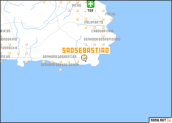
São Sebastião (Açores, Portugal)São Sebastião is a town in the Açores region of Portugal. An overview map of the region around São Sebastião is displayed below.
regional and 3d topo map of São Sebastião, Portugal ::
São Sebastião airports ::
The nearest airport is TER - Lajes (terceira Island) Lajes, located 12.4 km north of São Sebastião.
Other airports nearby include SJZ - Sao Jorge Island Sao Jorge (93.7 km west), GRW - Graciosa Island Graciosa (94.5 km north west), PIX - Pico (117.3 km west), HOR - Horta (141.5 km west), Nearby towns ::
Porto Judeu (1.4km west) //
Ribeira do Testo (2.9km west) //
Grota (2.9km west) //
Ribeira Seca (3.7km north) //
Fonte Bastardo (4.0km north) //
Santo António (4.7km north east) //
Porto Martins (4.7km north east) //
Recanto (4.7km north east) //
Senhora dos Remédios (4.7km north east) //
Senhora das Mercês (4.3km west) //
Outeiro (4.3km west) //
Feteira (4.3km west) //
Senhora da Esperança (4.7km south west) //
Álamos Bravos (6.3km north east) //
Cabo da Praia (6.3km north east) //
Ladeira Grande (5.8km west) //
Funduras (7.4km north) //
Casa da Ribeira (7.6km north) //
Vale Farto (7.6km north) //
Belo Jardim (8.0km north) //
[all distances 'as the bird flies' and approximate] 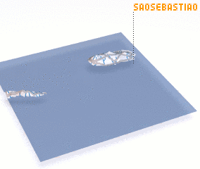 Places with similar names to São Sebastião, Portugal ::
// São Sebastião (BR)
// São Sebastião (BR)
// São Sebastião (BR)
// São Sebastião (BR)
// São Sebastião (BR)
// São Sebastião (BR)
// São Sebastião (BR)
// São Sebastião (BR)
// São Sebastião (BR)
// São Sebastião (BR)
Disclaimer :: Information on this page comes without warranty of any kind |
||
|
Where is São Sebastião? Elevation and coordinates ::
Latitude (lat): 38°39'0"N Longitude (lon): 27°6'0"W
Elevation (approx.): 33m (map arrows pan, magnifying glasses zoom) |
||
|
Visiting São Sebastião? Hotel/Accommodation ::
Book a hotel in São Sebastião Travel Guide ::
Buy a travel guide for Portugal rental cars ::
car rental offers GPS waypoint ::
download a GPX waypoint (PoI) of São Sebastião for your GPS receiver
|
||