|
search place name
|
||
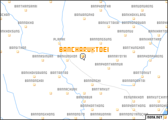
Ban Charuk Toei (Nakhon Phanom, Thailand)Ban Charuk Toei is a town in the Nakhon Phanom region of Thailand. An overview map of the region around Ban Charuk Toei is displayed below.
regional and 3d topo map of Ban Charuk Toei, Thailand ::
Ban Charuk Toei airports ::
The nearest airport is SNO - Sakon Nakhon, located 49.7 km west of Ban Charuk Toei.
Other airports nearby include ZVK - Savannakhet (68.3 km south), UTH - Udon Thani (192.7 km west), Nearby towns ::
Ban Na Dok Mai (2.6km north east) //
Ban Kung Kon (3.5km west) //
Ban Nong Sung (5.1km north east) //
Ban Kutakai (5.1km north east) //
Ban Nong Hi (5.8km south) //
Ban Phon Than Nua (5.6km east) //
Ban Tap Tao (6.5km south west) //
Pla Pak (6.5km north west) //
Ban Na Yo Yai (7.1km east) //
Ban Nong Kung (7.4km south) //
Ban Na Chuak (8.2km south west) //
Ban Tan Kut (8.2km south east) //
Ban Kut Ta Kai (9.1km north east) //
Amphoe Pla Pak (10.3km south west) //
[all distances 'as the bird flies' and approximate] 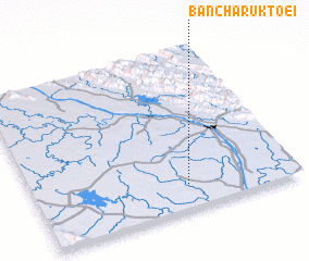 Places with similar names to Ban Charuk Toei, Thailand :: Disclaimer :: Information on this page comes without warranty of any kind |
||
|
Where is Ban Charuk Toei? Elevation and coordinates ::
Latitude (lat): 17°9'0"N Longitude (lon): 104°35'0"E
Elevation (approx.): 169m (map arrows pan, magnifying glasses zoom) |
||
|
Visiting Ban Charuk Toei? Hotel/Accommodation ::
Book a hotel in Ban Charuk Toei Travel Guide ::
Buy a travel guide for Thailand rental cars ::
car rental offers GPS waypoint ::
download a GPX waypoint (PoI) of Ban Charuk Toei for your GPS receiver
|
||