|
search place name
|
||
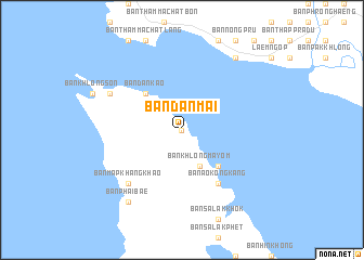
Ban Dan Mai (Trat, Thailand)Ban Dan Mai is a town in the Trat region of Thailand. An overview map of the region around Ban Dan Mai is displayed below.
regional and 3d topo map of Ban Dan Mai, Thailand ::
Ban Dan Mai airports ::
The nearest airport is UTP - Rayong U Taphao Intl, located 159.7 km north west of Ban Dan Mai.
Other airports nearby include REP - Siem-reap Siem Reap (215.1 km north east), BKK - Bangkok Intl (275.6 km north west), Nearby towns ::
Ban Khlong Nonsi (0.0km north) //
Ban Khlong Mayom (4.1km south east) //
Ban Dan Kao (5.2km north west) //
Ban Hat Sai Daeng (5.2km south east) //
Ban Ao Kongkang (6.6km south east) //
Ban Khlong Phrao (7.8km south west) //
Ban Map Khangkhao (7.8km south west) //
Ban Ao Sapparot (8.1km north west) //
Ban Phai Bae (9.2km south west) //
Ban Phai Bae (9.2km south west) //
Ban Laem Thong Lang (9.2km north east) //
[all distances 'as the bird flies' and approximate]  Places with similar names to Ban Dan Mai, Thailand ::
// Ban Daen Mi (TH)
// Ban Din Mo (TH)
// Ban Don I Mae (TH)
// Ban Don Mo (TH)
// Ban Don Moei (TH)
// Ban Don Mu (TH)
// Ban Don Mui (TH)
// Ban Don Mui (TH)
// Ban Na Don Mai (TH)
// Ban Na Don Mai (TH)
Disclaimer :: Information on this page comes without warranty of any kind |
||
|
Where is Ban Dan Mai? Elevation and coordinates ::
Latitude (lat): 12°6'0"N Longitude (lon): 102°21'0"E
Elevation (approx.): 83m (map arrows pan, magnifying glasses zoom) |
||
|
Visiting Ban Dan Mai? Hotel/Accommodation ::
Book a hotel in Ban Dan Mai Travel Guide ::
Buy a travel guide for Thailand rental cars ::
car rental offers GPS waypoint ::
download a GPX waypoint (PoI) of Ban Dan Mai for your GPS receiver
|
||