|
search place name
|
||
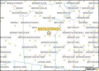
Ban Don Pho (2) (Phra Nakhon Si Ayutthaya, Thailand)Ban Don Pho (2) is a town in the Phra Nakhon Si Ayutthaya region of Thailand. An overview map of the region around Ban Don Pho (2) is displayed below.
regional and 3d topo map of Ban Don Pho (2), Thailand ::
Ban Don Pho (2) airports ::
The nearest airport is BKK - Bangkok Intl, located 49.1 km south east of Ban Don Pho (2).
Other airports nearby include HHQ - Prachuap Khiri Khan Hua Hin (185.1 km south), UTP - Rayong U Taphao Intl (190.0 km south), NAK - Nakhon Ratchasima Khorat (202.0 km east), MGZ - Myeik (274.3 km south west), Nearby towns ::
Ban Nong Lamchiak (1) (0.0km north) //
Ban Nong Khot (1) (1.8km west) //
Ban Khlong Khut (1) (1.8km east) //
Ban Nong O (2) (1.8km east) //
Ban Chao Paet (2) (3.6km east) //
Ban Rang Pik Kaeo (3.7km south) //
Ban Wang Chado (4.0km north west) //
Ban Don Thong (2) (4.1km south west) //
Ban Chai Na (5.2km north east) //
Ban Thaeo (5.2km north east) //
Ban Tao Lao (1) (5.6km north) //
Ban Rang Hoi Khom (1) (5.6km south) //
Ban Khok Luang Phon (5.7km east) //
Ban Nong Fuam (5.7km west) //
Ban Nai Thum (5.7km west) //
Ban Nai Thum (5.7km west) //
Ban Wua Non (6.6km south east) //
Ban U Taphao (2) (6.6km south east) //
Ban Nong Lom (6.5km south east) //
Ban Chorakhe Lai (2) (6.5km south west) //
Ban Bang Sai Nai (7.4km north) //
Ban Khok Chula (7.2km east) //
Ban Rang Hoi Khom (2) (7.4km south) //
Ban Mekkhala (7.4km south) //
Ban Nong Phaengphuai (2) (7.4km west) //
Ban Kraphang Khlon (7.6km south) //
Ban Khanon (1) (7.7km north east) //
Bang Sai (8.2km north west) //
Ban Don Kai Thuan (1) (8.1km north west) //
[all distances 'as the bird flies' and approximate]  Places with similar names to Ban Don Pho (2), Thailand ::
Disclaimer :: Information on this page comes without warranty of any kind |
||
|
Where is Ban Don Pho (2)? Elevation and coordinates ::
Latitude (lat): 14°16'0"N Longitude (lon): 100°20'0"E
Elevation (approx.): 5m (map arrows pan, magnifying glasses zoom) |
||
|
Visiting Ban Don Pho (2)? Hotel/Accommodation ::
Book a hotel in Ban Don Pho (2) Travel Guide ::
Buy a travel guide for Thailand rental cars ::
car rental offers GPS waypoint ::
download a GPX waypoint (PoI) of Ban Don Pho (2) for your GPS receiver
|
||