|
search place name
|
||
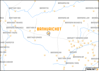
Ban Huai Chot (Prachin Buri, Thailand)Ban Huai Chot is a town in the Prachin Buri region of Thailand. An overview map of the region around Ban Huai Chot is displayed below.
regional and 3d topo map of Ban Huai Chot, Thailand ::
Ban Huai Chot airports ::
The nearest airport is NAK - Nakhon Ratchasima Khorat, located 130.3 km north of Ban Huai Chot.
Other airports nearby include REP - Siem-reap Siem Reap (175.4 km east), BKK - Bangkok Intl (176.6 km west), UTP - Rayong U Taphao Intl (179.4 km south west), Nearby towns ::
Ban Tha Kasem Nai (5.7km west) //
Ban Thung Phra (5.7km west) //
Ban Tha Kasem (7.4km west) //
Ban Bo Nang Ching (7.6km south) //
Ban Nong Paen (7.7km east) //
Ban Nong Wa (7.8km north east) //
Ban Nong Ma-u (7.8km north east) //
Ban Na Ngam (7.9km south) //
Ban Mueang (8.6km east) //
Ban Nong Saeng (8.8km east) //
Ban Hoi (9.1km south east) //
Ban Phrao (9.2km south east) //
Ban Rong Lueai (9.6km south east) //
[all distances 'as the bird flies' and approximate]  Places with similar names to Ban Huai Chot, Thailand ::
// Ban Huai Chiat (TH)
// Ban Huai Siat (TH)
// Ban Huai Siat (TH)
// Ban Houaychit (LA)
// Ban Houaychit (LA)
Disclaimer :: Information on this page comes without warranty of any kind |
||
|
Where is Ban Huai Chot? Elevation and coordinates ::
Latitude (lat): 13°46'0"N Longitude (lon): 102°14'0"E
Elevation (approx.): 63m (map arrows pan, magnifying glasses zoom) |
||
|
Visiting Ban Huai Chot? Hotel/Accommodation ::
Book a hotel in Ban Huai Chot Travel Guide ::
Buy a travel guide for Thailand rental cars ::
car rental offers GPS waypoint ::
download a GPX waypoint (PoI) of Ban Huai Chot for your GPS receiver
|
||