|
search place name
|
||
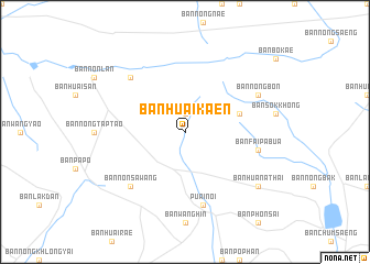
Ban Huai Kaen (Maha Sarakham, Thailand)Ban Huai Kaen is a town in the Maha Sarakham region of Thailand. An overview map of the region around Ban Huai Kaen is displayed below.
regional and 3d topo map of Ban Huai Kaen, Thailand ::
Ban Huai Kaen airports ::
The nearest airport is NAK - Nakhon Ratchasima Khorat, located 142.8 km south west of Ban Huai Kaen.
Other airports nearby include UTH - Udon Thani (159.4 km north), SNO - Sakon Nakhon (189.5 km north east), LOE - Loei (207.2 km north west), ZVK - Savannakhet (209.8 km east), Nearby towns ::
Ban Hin Hao (1.9km north) //
Ban Loeng Faek (5.7km east) //
Ban Hua Khua (7.6km south) //
Puai Noi (7.6km south) //
Ban Wang Muang (7.6km south) //
Ban Fai Pa Bua (7.4km east) //
Ban Non Sawang (7.7km south west) //
Ban Kut Chuak (7.7km north west) //
Ban Nong Bon (8.0km north east) //
Ban Hua Na Thai (9.0km south east) //
[all distances 'as the bird flies' and approximate]  Places with similar names to Ban Huai Kaen, Thailand ::
// Banhigan (PH)
// Binhagan (PH)
// Ban Hoi Kan (TH)
// Ban Huai Kan (TH)
// Ban Huai Kon (TH)
// Ban Huai Kon (TH)
// Ban Huai Kon (TH)
// Ban Houaygna (LA)
// Ban Houaygna (LA)
// Ban Houaygnai (LA)
Disclaimer :: Information on this page comes without warranty of any kind |
||
|
Where is Ban Huai Kaen? Elevation and coordinates ::
Latitude (lat): 15°57'0"N Longitude (lon): 102°54'0"E
Elevation (approx.): 203m (map arrows pan, magnifying glasses zoom) |
||
|
Visiting Ban Huai Kaen? Hotel/Accommodation ::
Book a hotel in Ban Huai Kaen Travel Guide ::
Buy a travel guide for Thailand rental cars ::
car rental offers GPS waypoint ::
download a GPX waypoint (PoI) of Ban Huai Kaen for your GPS receiver
|
||