|
search place name
|
||
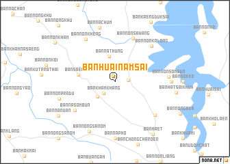
Ban Huai Nam Sai (Ubon Ratchathani, Thailand)Ban Huai Nam Sai is a town in the Ubon Ratchathani region of Thailand. An overview map of the region around Ban Huai Nam Sai is displayed below.
regional and 3d topo map of Ban Huai Nam Sai, Thailand ::
Ban Huai Nam Sai airports ::
The nearest airport is PKZ - Pakse, located 60.3 km north east of Ban Huai Nam Sai.
Other airports nearby include ZVK - Savannakhet (189.4 km north), REP - Siem-reap Siem Reap (228.9 km south west), Nearby towns ::
Ban Na Pho (2.1km east) //
Ban Kham Khang (2.6km south west) //
Ban Kham Khang (3.7km south west) //
Ban Na Thung (4.2km north) //
Ban Saen Suk (5.9km west) //
Ban Non Sawang (7.7km north) //
Ban Na Sombun (7.9km south west) //
Ban Non Ka Long (8.2km north east) //
Ban Non Kheng (8.3km north west) //
Ban Na Khaen (8.3km south east) //
Ban Non Sombun (8.6km east) //
Ban Nong Sanom (9.0km south west) //
Ban Maet (10.5km south east) //
[all distances 'as the bird flies' and approximate]  Places with similar names to Ban Huai Nam Sai, Thailand ::
// Ban Han Nam Sai (TH)
// Ban Huai Nam Sai (TH)
Disclaimer :: Information on this page comes without warranty of any kind |
||
|
Where is Ban Huai Nam Sai? Elevation and coordinates ::
Latitude (lat): 14°55'0"N Longitude (lon): 105°16'0"E
Elevation (approx.): 166m (map arrows pan, magnifying glasses zoom) |
||
|
Visiting Ban Huai Nam Sai? Hotel/Accommodation ::
Book a hotel in Ban Huai Nam Sai Travel Guide ::
Buy a travel guide for Thailand rental cars ::
car rental offers GPS waypoint ::
download a GPX waypoint (PoI) of Ban Huai Nam Sai for your GPS receiver
|
||