|
search place name
|
||
Ban Huang Nam Khao (Trat, Thailand)Ban Huang Nam Khao is a town in the Trat region of Thailand. An overview map of the region around Ban Huang Nam Khao is displayed below.
regional and 3d topo map of Ban Huang Nam Khao, Thailand ::

Ban Huang Nam Khao airports ::
The nearest airport is UTP - Rayong U Taphao Intl, located 179.2 km west of Ban Huang Nam Khao.
Other airports nearby include REP - Siem-reap Siem Reap (198.2 km north east), BKK - Bangkok Intl (289.7 km north west), Nearby towns ::
Ban Laem Ta Phan (2.6km south west) //
Ban Pret Nok (3.7km north) //
Ban Laem Sai (3.7km north) //
Ban Ao Yai (3.7km south) //
Ban Pret Nai (4.1km north west) //
Ban Ao Yuan (4.1km south east) //
Ban Ao Cho (5.6km south) //
Ban Laem Hin (5.6km north) //
Ban Laem Phrao (6.6km south east) //
Ban Laem Chan (7.4km south) //
Ban Khlong Po (7.4km south) //
Ban Nong Khan Song (7.6km north) //
Ban Ao Kham (7.6km south) //
Ban Laem Sok (8.3km south east) //
Ban Laem Po (8.3km south east) //
Ban Pak Khlong (9.1km north west) //
Ban Phrong Lam Bit (10.4km north west) //
[all distances 'as the bird flies' and approximate] 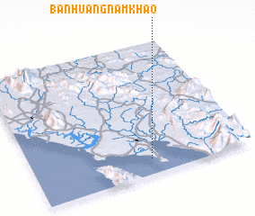 Places with similar names to Ban Huang Nam Khao, Thailand :: Disclaimer :: Information on this page comes without warranty of any kind |
||
|
Where is Ban Huang Nam Khao? Elevation and coordinates ::
Latitude (lat): 12°7'0"N Longitude (lon): 102°33'0"E
Elevation (approx.): 19m (map arrows pan, magnifying glasses zoom) |
||
|
Visiting Ban Huang Nam Khao? Hotel/Accommodation ::
Book a hotel in Ban Huang Nam Khao Travel Guide ::
Buy a travel guide for Thailand rental cars ::
car rental offers GPS waypoint ::
download a GPX waypoint (PoI) of Ban Huang Nam Khao for your GPS receiver
|
||