|
search place name
|
||
Ban Kaeng Ta Lo (Prachin Buri, Thailand)Ban Kaeng Ta Lo is a town in the Prachin Buri region of Thailand. An overview map of the region around Ban Kaeng Ta Lo is displayed below.
regional and 3d topo map of Ban Kaeng Ta Lo, Thailand ::

Ban Kaeng Ta Lo airports ::
The nearest airport is NAK - Nakhon Ratchasima Khorat, located 117.5 km north of Ban Kaeng Ta Lo.
Other airports nearby include BKK - Bangkok Intl (132.6 km west), UTP - Rayong U Taphao Intl (162.1 km south west), REP - Siem-reap Siem Reap (220.9 km east), HHQ - Prachuap Khiri Khan Hua Hin (247.2 km south west), Nearby towns ::
Ban Bu Chieo (0.0km north) //
Ban Khrai (1.8km east) //
Ban Kung (1.9km north) //
Ban Huai (1.9km north) //
Ban Non Pho (2.6km north east) //
Ban Bu Chan (2.6km south east) //
Ban Wang Kaeng (2.6km north east) //
Ban Nong Khla (3.6km west) //
Ban Kaeng (3.6km east) //
Ban Wang Hang (5.2km north west) //
Ban Bung Len (5.2km north west) //
Ban Nong Hoi (5.4km east) //
Ban Pak Nam (5.4km east) //
Ban Bo Thong (5.6km north) //
Ban Khlong Nang Ling Yai (5.8km south) //
Ban Nong Tang (5.7km west) //
Ban Non Sung (6.5km south east) //
Ban Tha Thong Dam (6.5km north west) //
Ban Non Daeng (6.5km north west) //
Ban Klang (6.6km south east) //
Ban Trok Pla Lai (7.2km west) //
Ban Wang Ri (2) (7.4km west) //
Ban Pat Moei (7.4km west) //
Ban Dan Phra Prong (7.4km east) //
Ban Wang Takhian (7.7km south east) //
Ban Chao Raeng (8.1km south west) //
Ban Nong Khae (8.2km north west) //
Ban Khok (8.2km south east) //
Ban Tha Khoi (9.1km north west) //
[all distances 'as the bird flies' and approximate] 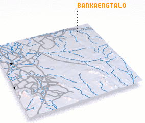 Places with similar names to Ban Kaeng Ta Lo, Thailand ::
Disclaimer :: Information on this page comes without warranty of any kind |
||
|
Where is Ban Kaeng Ta Lo? Elevation and coordinates ::
Latitude (lat): 13°54'0"N Longitude (lon): 101°50'0"E
Elevation (approx.): 13m (map arrows pan, magnifying glasses zoom) |
||
|
Visiting Ban Kaeng Ta Lo? Hotel/Accommodation ::
Book a hotel in Ban Kaeng Ta Lo Travel Guide ::
Buy a travel guide for Thailand rental cars ::
car rental offers GPS waypoint ::
download a GPX waypoint (PoI) of Ban Kaeng Ta Lo for your GPS receiver
|
||