|
search place name
|
||
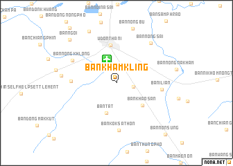
Ban Kham Kling (Udon Thani, Thailand)Ban Kham Kling is a town in the Udon Thani region of Thailand. An overview map of the region around Ban Kham Kling is displayed below.
regional and 3d topo map of Ban Kham Kling, Thailand ::
Ban Kham Kling airports ::
The nearest airport is UTH - Udon Thani, located 3.9 km north of Ban Kham Kling.
Other airports nearby include VTE - Vientiane Wattay Intl (74.7 km north), LOE - Loei (115.1 km west), SNO - Sakon Nakhon (141.1 km east), ZVK - Savannakhet (226.4 km south east), Nearby towns ::
Ban Dong Kheng (2.7km east) //
Ban Chang (4.1km north west) //
Ban Tat (5.1km south) //
Ban Khao San (5.4km south east) //
Udon Thani (6.1km north) //
Ban Khok Si Chiang Mai (7.0km west) //
Ban I Lian (7.0km east) //
Ban Kok Sathon (7.6km south) //
Ban Nong Khlong (7.7km north west) //
Ban Nong Sai (8.3km north east) //
Ban Bo Nam (8.6km west) //
Ban Nong Bu (9.1km north) //
Ban Liam (9.3km north west) //
Ban Ngoi (10.1km north west) //
Ban Non Sung (11.3km south east) //
[all distances 'as the bird flies' and approximate]  Places with similar names to Ban Kham Kling, Thailand ::
// Ban Kham Klang (TH)
// Ban Kham Klang (TH)
Disclaimer :: Information on this page comes without warranty of any kind |
||
|
Where is Ban Kham Kling? Elevation and coordinates ::
Latitude (lat): 17°21'11"N Longitude (lon): 102°48'5"E
Elevation (approx.): 190m (map arrows pan, magnifying glasses zoom) |
||
|
Visiting Ban Kham Kling? Hotel/Accommodation ::
Book a hotel in Ban Kham Kling Travel Guide ::
Buy a travel guide for Thailand rental cars ::
car rental offers GPS waypoint ::
download a GPX waypoint (PoI) of Ban Kham Kling for your GPS receiver
|
||