|
search place name
|
||
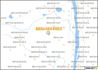
Ban Kham Phok (Nakhon Phanom, Thailand)Ban Kham Phok is a town in the Nakhon Phanom region of Thailand. An overview map of the region around Ban Kham Phok is displayed below.
regional and 3d topo map of Ban Kham Phok, Thailand ::
Ban Kham Phok airports ::
The nearest airport is SNO - Sakon Nakhon, located 64.3 km west of Ban Kham Phok.
Other airports nearby include ZVK - Savannakhet (80.6 km south), UTH - Udon Thani (205.3 km west), Nearby towns ::
Ban Kluai (4.0km south east) //
Ban Na Luang (4.0km north east) //
Ban Don Daeng (4.1km south west) //
Ban Kham That (4.1km north east) //
Ban Suk Kasem (5.8km north) //
Ban Chanot (6.5km south east) //
Ban Khok Klang (6.6km south west) //
Ban Phon Kho (8.2km south east) //
Ban Phon Pa Wan (8.2km south west) //
Ban Na Pong (9.0km north east) //
Ban Nong Chan (10.2km north east) //
Ban Dong Chok (10.2km north east) //
[all distances 'as the bird flies' and approximate]  Places with similar names to Ban Kham Phok, Thailand ::
// Ban Kham Phok (TH)
Disclaimer :: Information on this page comes without warranty of any kind |
||
|
Where is Ban Kham Phok? Elevation and coordinates ::
Latitude (lat): 17°17'0"N Longitude (lon): 104°43'0"E
Elevation (approx.): 161m (map arrows pan, magnifying glasses zoom) |
||
|
Visiting Ban Kham Phok? Hotel/Accommodation ::
Book a hotel in Ban Kham Phok Travel Guide ::
Buy a travel guide for Thailand rental cars ::
car rental offers GPS waypoint ::
download a GPX waypoint (PoI) of Ban Kham Phok for your GPS receiver
|
||