|
search place name
|
||
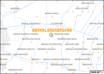
Ban Khlong Nong Kha (Samut Prakan, Thailand)Ban Khlong Nong Kha is a town in the Samut Prakan region of Thailand. An overview map of the region around Ban Khlong Nong Kha is displayed below.
regional and 3d topo map of Ban Khlong Nong Kha, Thailand ::
nearby GPS traces from timatio ::
Ban Khlong Nong Kha airports ::
The nearest airport is BKK - Bangkok Intl, located 30.7 km north west of Ban Khlong Nong Kha.
Other airports nearby include UTP - Rayong U Taphao Intl (114.0 km south), HHQ - Prachuap Khiri Khan Hua Hin (145.7 km south west), NAK - Nakhon Ratchasima Khorat (198.0 km north east), Nearby towns ::
Ban Khlong Mon (3.6km east) //
Ban Khlong Nong Pru (3.7km south) //
Lat Krabang (4.1km north east) //
Lat Krabang (4.1km north east) //
Ban Hua Takhe (5.2km north east) //
Ban Bang Sao Thong (5.7km east) //
Ban Bang Chalong (5.8km south) //
Ban Khlong Si (7.4km north) //
Ban Khlong Thewa (7.4km west) //
Ban Chuat Bua (8.1km south east) //
Ban Khlong Prawet (8.1km north west) //
Ban Khlong Lat Bua Khao (9.2km north west) //
Ban Map Prasoe (10.3km south west) //
[all distances 'as the bird flies' and approximate] 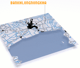 Places with similar names to Ban Khlong Nong Kha, Thailand :: Disclaimer :: Information on this page comes without warranty of any kind |
||
|
Where is Ban Khlong Nong Kha? Elevation and coordinates ::
Latitude (lat): 13°41'0"N Longitude (lon): 100°46'0"E
Elevation (approx.): 2m (map arrows pan, magnifying glasses zoom) |
||
|
Visiting Ban Khlong Nong Kha? Hotel/Accommodation ::
Book a hotel in Ban Khlong Nong Kha Travel Guide ::
Buy a travel guide for Thailand rental cars ::
car rental offers GPS waypoint ::
download a GPX waypoint (PoI) of Ban Khlong Nong Kha for your GPS receiver
|
||