|
search place name
|
||
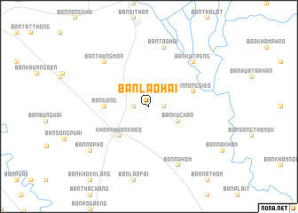
Ban Lao Hai (Yasothon, Thailand)Ban Lao Hai is a town in the Yasothon region of Thailand. An overview map of the region around Ban Lao Hai is displayed below.
regional and 3d topo map of Ban Lao Hai, Thailand ::
Ban Lao Hai airports ::
The nearest airport is ZVK - Savannakhet, located 106.1 km north east of Ban Lao Hai.
Other airports nearby include PKZ - Pakse (165.3 km east), SNO - Sakon Nakhon (169.1 km north), UTH - Udon Thani (251.6 km north west), Nearby towns ::
Ban Khi Lek (1.8km west) //
Ban Nong Kop (1.8km east) //
Ban Ku Chan (4.0km south east) //
Kham Khuan Kaeo (5.1km south west) //
Ban Dong (5.4km west) //
Ban Nong Sieo (5.7km east) //
Ban Tao Hai (7.6km north) //
Ban Thung Mon (7.7km north west) //
Ban Kut Peng (7.7km north east) //
Ban Na Hom (8.2km south east) //
Ban Na Pho (9.0km south west) //
[all distances 'as the bird flies' and approximate]  Places with similar names to Ban Lao Hai, Thailand ::
// Binolho (PH)
// Ban Lai Huai (TH)
// Banualuhu (ID)
// Bonelohe (ID)
// Ban Laha (LA)
// Ban Laha (LA)
// Ban Laheuy (LA)
// Ban Laho (LA)
// Ban Laho (LA)
// Ban Laohua (LA)
Disclaimer :: Information on this page comes without warranty of any kind |
||
|
Where is Ban Lao Hai? Elevation and coordinates ::
Latitude (lat): 15°41'0"N Longitude (lon): 104°21'0"E
Elevation (approx.): 135m (map arrows pan, magnifying glasses zoom) |
||
|
Visiting Ban Lao Hai? Hotel/Accommodation ::
Book a hotel in Ban Lao Hai Travel Guide ::
Buy a travel guide for Thailand rental cars ::
car rental offers GPS waypoint ::
download a GPX waypoint (PoI) of Ban Lao Hai for your GPS receiver
|
||