|
search place name
|
||
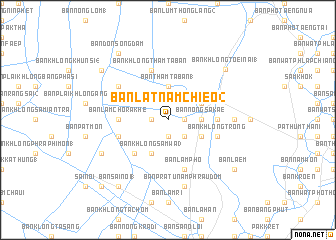
Ban Lat Nam Chieo (2) (Pathum Thani, Thailand)Ban Lat Nam Chieo (2) is a town in the Pathum Thani region of Thailand. An overview map of the region around Ban Lat Nam Chieo (2) is displayed below.
regional and 3d topo map of Ban Lat Nam Chieo (2), Thailand ::
Ban Lat Nam Chieo (2) airports ::
The nearest airport is BKK - Bangkok Intl, located 26.0 km south east of Ban Lat Nam Chieo (2).
Other airports nearby include HHQ - Prachuap Khiri Khan Hua Hin (162.0 km south), UTP - Rayong U Taphao Intl (163.4 km south east), NAK - Nakhon Ratchasima Khorat (206.6 km north east), MGZ - Myeik (261.2 km south west), Nearby towns ::
Ban Khlong Sakae (1) (1.9km south) //
Lat Lum Kaeo (1.8km east) //
Ban Lat Chang (1) (1.8km west) //
Ban Lat Lum Kaeo (1) (2.6km south east) //
Ban Nong Sakae (3.6km east) //
Ban Lam Phaya Riang (3.7km north) //
Ban Plai Khlong Tham Ta Ban (3.7km north) //
Ban Tham Ta Ban (1) (3.7km north) //
Ban Lat Lum Kaeo (3) (4.0km south east) //
Ban Khu Bang Luang (4.0km north east) //
Ban Khlong Sam Wa (3) (4.1km south west) //
Ban Ang Taek (5.2km south west) //
Ban Khlong Chao (5.4km east) //
Ban Lam Chorakhe (5.4km west) //
Ban Khlong Trong (5.7km east) //
Ban Khlong Ta Khlai (5.7km west) //
Ban Khlong Lak Khon (1) (5.7km west) //
Ban Lam Pho (5.8km south) //
Ban Khlong Tham Taban (5.8km north) //
Ban Plai Khlong Rahaeng (1) (6.5km north west) //
Ban Khlong Bang Luang (1) (7.2km east) //
Ban Pratu Nam Phra Udom (7.6km south) //
Ban Khlong Ha Roi (5) (8.1km south west) //
Ban Khlong Toei Nai (1) (8.4km north east) //
Ban Sai Noi (1) (9.2km south west) //
Ban Khlong Ha Roi (2) (9.1km north west) //
Ban Laem (9.1km south east) //
Ban Don Song Dam (9.2km north west) //
Ban Sai Yai (2) (10.3km south west) //
[all distances 'as the bird flies' and approximate]  Places with similar names to Ban Lat Nam Chieo (2), Thailand :: Disclaimer :: Information on this page comes without warranty of any kind |
||
|
Where is Ban Lat Nam Chieo (2)? Elevation and coordinates ::
Latitude (lat): 14°2'0"N Longitude (lon): 100°24'0"E
Elevation (approx.): 4m (map arrows pan, magnifying glasses zoom) |
||
|
Visiting Ban Lat Nam Chieo (2)? Hotel/Accommodation ::
Book a hotel in Ban Lat Nam Chieo (2) Travel Guide ::
Buy a travel guide for Thailand rental cars ::
car rental offers GPS waypoint ::
download a GPX waypoint (PoI) of Ban Lat Nam Chieo (2) for your GPS receiver
|
||