|
search place name
|
||
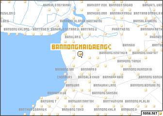
Ban Nong Mai Daeng (2) (Chon Buri, Thailand)Ban Nong Mai Daeng (2) is a town in the Chon Buri region of Thailand. An overview map of the region around Ban Nong Mai Daeng (2) is displayed below.
regional and 3d topo map of Ban Nong Mai Daeng (2), Thailand ::
Ban Nong Mai Daeng (2) airports ::
The nearest airport is BKK - Bangkok Intl, located 70.5 km north west of Ban Nong Mai Daeng (2).
Other airports nearby include UTP - Rayong U Taphao Intl (81.5 km south), HHQ - Prachuap Khiri Khan Hua Hin (144.2 km south west), NAK - Nakhon Ratchasima Khorat (203.3 km north east), Nearby towns ::
Ban Don Lang (1.8km east) //
Ban Si Phalo (1.8km west) //
Ban Nai (2.6km north west) //
Ban Tamru (2.6km north west) //
Ban Hua Thong Lang (2.6km south west) //
Ban Don Bon (3.6km east) //
Ban Chak Samo (3.6km east) //
Ban Lang Khao (3.7km south) //
Ban Nong Chap Ung (4.1km south east) //
Ban Klang (4.1km north west) //
Ban Na Pa (1) (4.1km south east) //
Ban Khlong Kao (5.2km north west) //
Ban Bang Sai (5.2km south west) //
Ban Khlong Phan Thong (5.6km north) //
Ban Nong Din Daeng (5.7km east) //
Ban Yan Su (5.8km north) //
Ban Na Khuan (5.8km south) //
Ban Sala Khu (1) (5.8km south) //
Ban Nong Tamlung (5.7km east) //
Ban Nong Faep (5.7km east) //
Ban Khlong Khet (6.6km north west) //
Ban Khlong Tamru (6.6km north west) //
Chon Buri (6.6km south west) //
Ban Pak Khlong Phan Thong (7.4km north) //
Ban Nong Krathum (7.2km east) //
Ban Nong Krang (7.4km south) //
Ban Nong Khai Nao (7.6km south) //
Ban Nong Tako (7.6km south) //
Ban Suan (7.6km south) //
[all distances 'as the bird flies' and approximate]  Places with similar names to Ban Nong Mai Daeng (2), Thailand :: Disclaimer :: Information on this page comes without warranty of any kind |
||
|
Where is Ban Nong Mai Daeng (2)? Elevation and coordinates ::
Latitude (lat): 13°25'0"N Longitude (lon): 101°1'0"E
Elevation (approx.): 5m (map arrows pan, magnifying glasses zoom) |
||
|
Visiting Ban Nong Mai Daeng (2)? Hotel/Accommodation ::
Book a hotel in Ban Nong Mai Daeng (2) Travel Guide ::
Buy a travel guide for Thailand rental cars ::
car rental offers GPS waypoint ::
download a GPX waypoint (PoI) of Ban Nong Mai Daeng (2) for your GPS receiver
|
||