|
search place name
|
||
Ban Phru Kachaeng (Surat Thani, Thailand)Ban Phru Kachaeng is a town in the Surat Thani region of Thailand. An overview map of the region around Ban Phru Kachaeng is displayed below.
regional and 3d topo map of Ban Phru Kachaeng, Thailand ::

Ban Phru Kachaeng airports ::
The nearest airport is NST - Nakhon Si Thammarat Cha Ian, located 61.0 km east of Ban Phru Kachaeng.
Other airports nearby include TST - Trang (122.7 km south), HKT - Phuket Intl (132.6 km south west), HDY - Songkhla Hat Yai Intl (213.5 km south east), PAN - Pattani (277.5 km south east), Nearby towns ::
Ban Khao Khap (2.6km south west) //
Ban Phru Khi Kla (4.1km south east) //
Ban Thung Kha (4.1km north west) //
Ban Na Chum Het (5.2km south east) //
Wiang Sa (5.2km north west) //
Ban Sai Hong (5.9km north) //
Ban Phlu Thuan (5.8km west) //
Ban Song (6.6km north west) //
Ban Khlong Ka (6.6km south east) //
Ban Huai Prik (6.6km south east) //
Ban Na Yaek (7.6km south) //
Ban Bua Ngam (7.8km south east) //
Ban Na Sanya (8.2km south east) //
Ban Khao Niphan (8.2km south west) //
Wiang Sa (8.2km north west) //
Ban Nam Thao (8.3km north west) //
Ban Hua Saphan (9.2km north west) //
[all distances 'as the bird flies' and approximate] 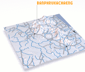 Places with similar names to Ban Phru Kachaeng, Thailand :: Disclaimer :: Information on this page comes without warranty of any kind |
||
|
Where is Ban Phru Kachaeng? Elevation and coordinates ::
Latitude (lat): 8°36'0"N Longitude (lon): 99°25'0"E
Elevation (approx.): 68m (map arrows pan, magnifying glasses zoom) |
||
|
Visiting Ban Phru Kachaeng? Hotel/Accommodation ::
Book a hotel in Ban Phru Kachaeng Travel Guide ::
Buy a travel guide for Thailand rental cars ::
car rental offers GPS waypoint ::
download a GPX waypoint (PoI) of Ban Phru Kachaeng for your GPS receiver
|
||