|
search place name
|
||
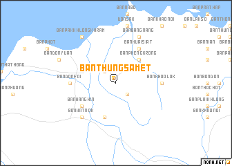
Ban Thung Samet (Surat Thani, Thailand)Ban Thung Samet is a town in the Surat Thani region of Thailand. An overview map of the region around Ban Thung Samet is displayed below.
regional and 3d topo map of Ban Thung Samet, Thailand ::
Ban Thung Samet airports ::
The nearest airport is NST - Nakhon Si Thammarat Cha Ian, located 88.4 km south of Ban Thung Samet.
Other airports nearby include TST - Trang (189.0 km south), HKT - Phuket Intl (192.3 km south west), Nearby towns ::
Ban Khuan Taeo (2.6km north west) //
Ban Tha Pling (2.6km south east) //
Ban Pheng Krong (5.2km north east) //
Ban Din Daeng (1) (5.9km south) //
Ban Huai Siat (6.7km north east) //
Ban Wang Hin (6.6km south west) //
Ban Khao Lak (7.3km east) //
Ban Don Fai (7.3km west) //
Ban Wat Nok (7.8km south west) //
Ban Bang Nang (8.3km north east) //
Ban Pak Khlong Khram (9.2km north west) //
[all distances 'as the bird flies' and approximate] 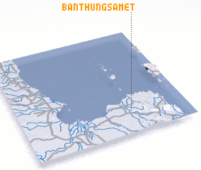 Places with similar names to Ban Thung Samet, Thailand :: Disclaimer :: Information on this page comes without warranty of any kind |
||
|
Where is Ban Thung Samet? Elevation and coordinates ::
Latitude (lat): 9°13'0"N Longitude (lon): 99°40'0"E
Elevation (approx.): 74m (map arrows pan, magnifying glasses zoom) |
||
|
Visiting Ban Thung Samet? Hotel/Accommodation ::
Book a hotel in Ban Thung Samet Travel Guide ::
Buy a travel guide for Thailand rental cars ::
car rental offers GPS waypoint ::
download a GPX waypoint (PoI) of Ban Thung Samet for your GPS receiver
|
||