|
search place name
|
||
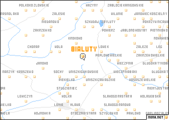
Białuty (Poland)Białuty is a town in Poland. An overview map of the region around Białuty is displayed below.
regional and 3d topo map of Białuty, Poland ::
Białuty airports ::
The nearest airport is WAW - Warsaw Okecie, located 123.1 km south of Białuty.
Other airports nearby include GDN - Gdansk Lecha Walesy (181.5 km north west), KGD - Kaliningrad Khrabrovo (186.7 km north), Nearby towns ::
Uniszki Gumowskie (3.7km south) //
Napierki (2.9km north east) //
Pepłówek (2.9km north east) //
Krokowo (3.9km north) //
Dźwierznia (3.9km south) //
Krajewo (5.6km south) //
Pepłowo Wielkie (3.3km east) //
Wola (3.8km north west) //
Piekiełko (6.0km south) //
Michalinowo (6.0km south) //
Uniszki Zawadzkie (6.0km south) //
Sochy (5.0km south west) //
Kuklin (5.0km south east) //
Bartki (7.4km north) //
Kulany (4.4km east) //
Szkudaj (7.5km north) //
Górowo (7.5km north) //
Purgałki (4.8km north west) //
Powierz (6.5km north east) //
Studzieniec (7.7km south) //
Zbyluty (8.1km north east) //
Mławka (8.1km south west) //
Niedanowo (8.6km north west) //
[all distances 'as the bird flies' and approximate] 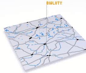 Places with similar names to Białuty, Poland ::
Disclaimer :: Information on this page comes without warranty of any kind |
||
|
Where is Białuty? Elevation and coordinates ::
Latitude (lat): 53°13'0"N Longitude (lon): 20°24'0"E
Elevation (approx.): 176m (map arrows pan, magnifying glasses zoom) |
||
|
Visiting Białuty? Hotel/Accommodation ::
Book a hotel in Białuty Travel Guide ::
Buy a travel guide for Poland rental cars ::
car rental offers GPS waypoint ::
download a GPX waypoint (PoI) of Białuty for your GPS receiver
|
||