|
search place name
|
||
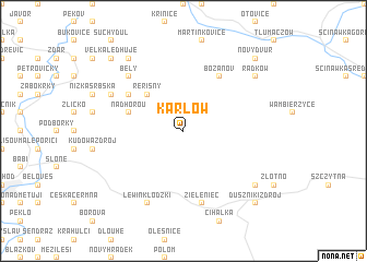
Karłów (Poland)Karłów is a town in Poland. An overview map of the region around Karłów is displayed below.
regional and 3d topo map of Karłów, Poland ::
Karłów airports ::
The nearest airport is PED - Pardubice, located 65.9 km south west of Karłów.
Other airports nearby include WRO - Wroclaw Strachowice (80.8 km north east), PRV - Prerov (139.0 km south east), BRQ - Turany (148.6 km south), BBJ - Bautzen (151.2 km north west), Nearby towns ::
Řeřišný (4.4km north west) //
Nad Horou (4.0km north west) //
Machovská Lhota (5.1km north west) //
Božanov (6.0km north east) //
Zieleniec (7.5km south) //
Bělý (6.6km north west) //
Machov (6.0km north west) //
Lewin Kłodzki (7.8km south) //
Slavný (8.2km north west) //
Dolina (7.3km south east) //
Radków (7.3km north east) //
Velká Ledhuje (8.8km north west) //
Nový Dvŭr (8.8km north east) //
Duszniki Zdrój (8.8km south east) //
[all distances 'as the bird flies' and approximate]  Places with similar names to Karłów, Poland ::
Disclaimer :: Information on this page comes without warranty of any kind |
||
|
Where is Karłów? Elevation and coordinates ::
Latitude (lat): 50°28'0"N Longitude (lon): 16°20'0"E
Elevation (approx.): 859m (map arrows pan, magnifying glasses zoom) |
||
|
Visiting Karłów? Hotel/Accommodation ::
Book a hotel in Karłów Travel Guide ::
Buy a travel guide for Poland rental cars ::
car rental offers GPS waypoint ::
download a GPX waypoint (PoI) of Karłów for your GPS receiver
|
||