|
search place name
|
||
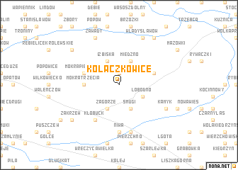
Kołaczkowice (Poland)Kołaczkowice is a town in Poland. An overview map of the region around Kołaczkowice is displayed below.
regional and 3d topo map of Kołaczkowice, Poland ::
Kołaczkowice airports ::
The nearest airport is KTW - Katowice Pyrzowice, located 53.5 km south of Kołaczkowice.
Other airports nearby include KRK - Krakow Balice (113.1 km south east), OSR - Ostrava Mosnov (152.2 km south west), PRV - Prerov (202.9 km south west), TAT - Poprad Tatry (227.8 km south east), Nearby towns ::
Wapiennik (1.9km north) //
Miedzno (3.9km north) //
Smugi (3.9km south) //
Izbiska (3.9km north) //
Łobodno (3.0km south east) //
Zagórze (3.9km south) //
Mokra Trzecia (3.5km west) //
Dębnik (4.0km north east) //
Mokra Druga (4.0km north west) //
Mokra (4.0km north west) //
Mokra Pierwsza (4.0km north west) //
Kłobuck (6.0km south west) //
Niwa (7.4km south) //
Libidza (7.5km south) //
Kamyk (6.0km south east) //
Władysławów (7.8km north) //
Zawady (7.8km north) //
Borowa (8.2km north east) //
Kamieńszczyzna (7.3km north west) //
Zakrzew (7.3km south west) //
[all distances 'as the bird flies' and approximate]  Places with similar names to Kołaczkowice, Poland ::
Disclaimer :: Information on this page comes without warranty of any kind |
||
|
Where is Kołaczkowice? Elevation and coordinates ::
Latitude (lat): 50°57'0"N Longitude (lon): 18°58'0"E
Elevation (approx.): 234m (map arrows pan, magnifying glasses zoom) |
||
|
Visiting Kołaczkowice? Hotel/Accommodation ::
Book a hotel in Kołaczkowice Travel Guide ::
Buy a travel guide for Poland rental cars ::
car rental offers GPS waypoint ::
download a GPX waypoint (PoI) of Kołaczkowice for your GPS receiver
|
||