|
search place name
|
||
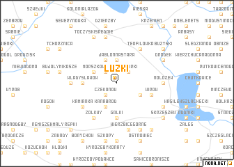
Łużki (Poland)Łużki is a town in Poland. An overview map of the region around Łużki is displayed below.
regional and 3d topo map of Łużki, Poland ::
Łużki airports ::
The nearest airport is WAW - Warsaw Okecie, located 106.0 km west of Łużki.
Nearby towns ::
Jabłonna Lacka (2.2km north west) //
Niemirki (2.2km north east) //
Czekanów (2.2km south west) //
Jabłonna Stara (3.7km north) //
Jabłonna (3.7km north) //
Jabłonna Średnia (3.9km north) //
Morszków (2.9km north west) //
Kanabród (3.9km south) //
Nowomodna (2.9km south east) //
Władysławów (3.4km west) //
Gałki (5.6km south) //
Wirów (3.9km south east) //
Teofilówka (6.0km north) //
Kamianka (5.0km south west) //
Żółkwy (6.0km south) //
Mołożew (4.5km east) //
Wierzbice Strupki (4.5km west) //
Toczyski Podborne (7.5km north) //
Wierzbice Górne (7.5km south) //
Gródek (5.8km north east) //
Toczyski Średnie (7.7km north) //
Wasilew Skrzeszewski (5.8km south east) //
Karskie (7.8km south) //
Bużyski (7.2km north east) //
Skrzeszew (7.2km south east) //
Liszki (8.2km south east) //
Repki (8.7km south west) //
[all distances 'as the bird flies' and approximate]  Places with similar names to Łużki, Poland ::
Disclaimer :: Information on this page comes without warranty of any kind |
||
|
Where is Łużki? Elevation and coordinates ::
Latitude (lat): 52°27'0"N Longitude (lon): 22°27'0"E
Elevation (approx.): 133m (map arrows pan, magnifying glasses zoom) |
||
|
Visiting Łużki? Hotel/Accommodation ::
Book a hotel in Łużki Travel Guide ::
Buy a travel guide for Poland rental cars ::
car rental offers GPS waypoint ::
download a GPX waypoint (PoI) of Łużki for your GPS receiver
|
||