|
search place name
|
||
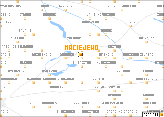
Maciejewo (Poland)Maciejewo is a town in Poland. An overview map of the region around Maciejewo is displayed below.
regional and 3d topo map of Maciejewo, Poland ::
Maciejewo airports ::
The nearest airport is POZ - Poznan Lawica, located 54.5 km north of Maciejewo.
Other airports nearby include IEG - Zielona Gora Babimost (69.2 km west), WRO - Wroclaw Strachowice (92.9 km south), SZZ - Szczechin Goleniow (222.1 km north west), PED - Pardubice (225.1 km south), Nearby towns ::
Ziemnice (0.0km north) //
Świerczyna (1.9km south) //
Kąty (1.9km north) //
Wojnowice (2.3km west) //
Górka (2.3km east) //
Czerwona Wieś (2.9km north east) //
Zgliniec (3.9km north) //
Miąskowo (3.4km east) //
Frankowo (5.6km south) //
Kleszczewo (3.9km south east) //
Jurkowo Huby (5.7km north) //
Jurkowo (6.0km north) //
Górzno (6.0km south) //
Grodzisko (6.0km south) //
Teklimyśl (4.6km east) //
Januszewo (7.5km north) //
Krzywiń (4.9km east) //
Świniec (6.5km north east) //
Garzyn (7.8km south) //
Osieczna (5.9km south west) //
Kąkolewo (8.2km south west) //
Łoniewo (7.2km south west) //
Zbytki (8.7km south east) //
[all distances 'as the bird flies' and approximate]  Places with similar names to Maciejewo, Poland ::
Disclaimer :: Information on this page comes without warranty of any kind |
||
|
Where is Maciejewo? Elevation and coordinates ::
Latitude (lat): 51°56'0"N Longitude (lon): 16°45'0"E
Elevation (approx.): 91m (map arrows pan, magnifying glasses zoom) |
||
|
Visiting Maciejewo? Hotel/Accommodation ::
Book a hotel in Maciejewo Travel Guide ::
Buy a travel guide for Poland rental cars ::
car rental offers GPS waypoint ::
download a GPX waypoint (PoI) of Maciejewo for your GPS receiver
|
||