|
search place name
|
||
Słoja (Poland)Słoja is a town in Poland. An overview map of the region around Słoja is displayed below.
regional and 3d topo map of Słoja, Poland ::
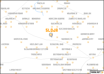
Nearby towns ::
Knyszewicze (1.1km east) //
Horczaki Dolne (3.7km north) //
Nowinka (3.9km south) //
Szudziałowo (3.9km south) //
Suchinicze (3.9km north) //
Sukowicze (3.8km south east) //
Horczaki Górne (5.7km north) //
Szczęsnowicze (3.8km north east) //
Kozłowy Łuh (5.0km south west) //
Boratynszczyzna (5.0km south west) //
Bohoniki (6.5km north west) //
Słójka Borowszczyzna (6.5km south west) //
Bobrowniki (6.5km north west) //
Ostrówek (6.5km south east) //
Ostrów Północny (7.7km south) //
Babiki (5.8km north east) //
Talkowszczyzna (8.1km south west) //
Trościano (8.1km south west) //
Wojnowce (8.6km north east) //
[all distances 'as the bird flies' and approximate] 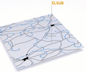 Places with similar names to Słoja, Poland ::
Disclaimer :: Information on this page comes without warranty of any kind |
||
|
Where is Słoja? Elevation and coordinates ::
Latitude (lat): 53°20'0"N Longitude (lon): 23°39'0"E
Elevation (approx.): 166m (map arrows pan, magnifying glasses zoom) |
||
|
Visiting Słoja? Hotel/Accommodation ::
Book a hotel in Słoja Travel Guide ::
Buy a travel guide for Poland rental cars ::
car rental offers GPS waypoint ::
download a GPX waypoint (PoI) of Słoja for your GPS receiver
|
||