|
search place name
|
||
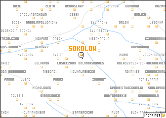
Sokołów (Poland)Sokołów is a town in Poland. An overview map of the region around Sokołów is displayed below.
regional and 3d topo map of Sokołów, Poland ::
Sokołów airports ::
The nearest airport is WAW - Warsaw Okecie, located 56.4 km east of Sokołów.
Other airports nearby include KTW - Katowice Pyrzowice (195.7 km south west), RZE - Rzeszow Jasionka (257.2 km south east), Nearby towns ::
Ziąbki (2.2km north east) //
Bolimowska Wieś (2.2km south east) //
Bolimów (2.2km south east) //
Kęszyce (3.7km north) //
Karolew (2.3km west) //
Wólka Łasiecka (3.7km south) //
Łasieczniki (2.9km south west) //
Kurabka (2.9km north east) //
Mizerka Nowa (4.3km north east) //
Sypień (3.4km west) //
Mizerka Stara (5.7km north) //
Mizerka (5.7km north) //
Żylin Folwark (5.7km north) //
Patoki (5.0km north west) //
Żylin Stary (6.0km north) //
Sucha Stara (6.0km north) //
Ziemiary (6.0km south) //
Kozłów Szlachecki (7.4km north) //
Sucha Nowa (6.5km north east) //
Piaski (6.5km south west) //
Nieborów (5.9km south west) //
Żylin Nowy (7.8km north) //
Leonów (8.7km north east) //
Grabie (8.7km south east) //
[all distances 'as the bird flies' and approximate]  Places with similar names to Sokołów, Poland ::
Disclaimer :: Information on this page comes without warranty of any kind |
||
|
Where is Sokołów? Elevation and coordinates ::
Latitude (lat): 52°6'0"N Longitude (lon): 20°9'0"E
Elevation (approx.): 86m (map arrows pan, magnifying glasses zoom) |
||
|
Visiting Sokołów? Hotel/Accommodation ::
Book a hotel in Sokołów Travel Guide ::
Buy a travel guide for Poland rental cars ::
car rental offers GPS waypoint ::
download a GPX waypoint (PoI) of Sokołów for your GPS receiver
|
||