|
search place name
|
||
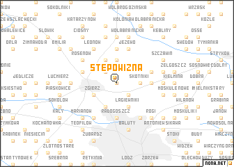
Stępowizna (Poland)Stępowizna is a town in Poland. An overview map of the region around Stępowizna is displayed below.
regional and 3d topo map of Stępowizna, Poland ::
Stępowizna airports ::
The nearest airport is WAW - Warsaw Okecie, located 109.3 km east of Stępowizna.
Other airports nearby include KTW - Katowice Pyrzowice (157.1 km south), KRK - Krakow Balice (200.4 km south), Nearby towns ::
Łagiewniki Stare (0.0km north) //
Rudunki (2.2km north west) //
Łagiewniki Nowe (2.2km south east) //
Dąbrówka Strumiany (3.7km north) //
Skotniki (2.3km east) //
Dąbrówka Wielka (3.9km north) //
Zgierz (2.9km south west) //
Helenówek (3.9km south) //
Łagiewniki (3.9km south) //
Głowa (5.6km north) //
Janów (3.4km east) //
Radogoszcz (5.6km south) //
Glinnik (3.9km north east) //
Proboszczewice (3.9km north west) //
Jeżewo (5.7km north) //
Leonów (6.0km north) //
Rosenów (5.1km north west) //
Żabieniec (6.0km south) //
Marysin (6.0km south) //
Biała (7.4km north) //
Bazylia (4.6km west) //
Józefów (4.6km east) //
Swoboda (7.5km north) //
Dzierzązna (7.5km north) //
Wola Branicka (7.5km north) //
Czaplinek (4.9km east) //
Modrzew (4.9km east) //
Bałuty (7.5km south) //
Rogi (6.5km south east) //
[all distances 'as the bird flies' and approximate]  Places with similar names to Stępowizna, Poland :: Disclaimer :: Information on this page comes without warranty of any kind |
||
|
Where is Stępowizna? Elevation and coordinates ::
Latitude (lat): 51°52'0"N Longitude (lon): 19°27'0"E
Elevation (approx.): 196m (map arrows pan, magnifying glasses zoom) |
||
|
Visiting Stępowizna? Hotel/Accommodation ::
Book a hotel in Stępowizna Travel Guide ::
Buy a travel guide for Poland rental cars ::
car rental offers GPS waypoint ::
download a GPX waypoint (PoI) of Stępowizna for your GPS receiver
|
||