|
search place name
|
||
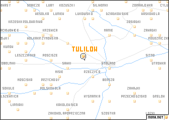
Tuliłów (Poland)Tuliłów is a town in Poland. An overview map of the region around Tuliłów is displayed below.
regional and 3d topo map of Tuliłów, Poland ::
Tuliłów airports ::
The nearest airport is WAW - Warsaw Okecie, located 122.5 km west of Tuliłów.
Other airports nearby include RZE - Rzeszow Jasionka (216.1 km south), Nearby towns ::
Żabce (1.9km north) //
Rzeczyca (3.9km south) //
Sawki (2.9km south west) //
Jelnica (2.9km south west) //
Tłuściec (4.4km north west) //
Międzyrzec Podlaski (3.9km south east) //
Stołpno (3.9km south east) //
Misie (5.0km south west) //
Pościsze (4.6km west) //
Bereza (6.5km south east) //
Manie (6.5km north east) //
Grabowiec (7.8km south) //
Przychody (7.2km south west) //
Krzewica (7.2km north west) //
Polskowola (8.7km south west) //
[all distances 'as the bird flies' and approximate]  Places with similar names to Tuliłów, Poland ::
Disclaimer :: Information on this page comes without warranty of any kind |
||
|
Where is Tuliłów? Elevation and coordinates ::
Latitude (lat): 52°0'0"N Longitude (lon): 22°44'0"E
Elevation (approx.): 152m (map arrows pan, magnifying glasses zoom) |
||
|
Visiting Tuliłów? Hotel/Accommodation ::
Book a hotel in Tuliłów Travel Guide ::
Buy a travel guide for Poland rental cars ::
car rental offers GPS waypoint ::
download a GPX waypoint (PoI) of Tuliłów for your GPS receiver
|
||