|
search place name
|
||
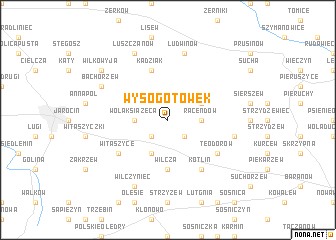
Wysogotówek (Poland)Wysogotówek is a town in Poland. An overview map of the region around Wysogotówek is displayed below.
regional and 3d topo map of Wysogotówek, Poland ::
Wysogotówek airports ::
The nearest airport is POZ - Poznan Lawica, located 74.0 km north west of Wysogotówek.
Other airports nearby include WRO - Wroclaw Strachowice (108.7 km south west), IEG - Zielona Gora Babimost (126.2 km west), KTW - Katowice Pyrzowice (195.0 km south east), PED - Pardubice (254.2 km south west), Nearby towns ::
Twardów (2.2km south east) //
Wyszki (2.2km south west) //
Racendów (2.3km east) //
Słupia (2.3km west) //
Wola Książęca (2.3km west) //
Lubinia Mała (2.9km north east) //
Magnuszewice (3.9km south) //
Wilcza (5.6km south) //
Kadziak (5.7km north) //
Kotlin (6.0km south) //
Teodorów (5.0km south east) //
Witaszyce (5.0km south west) //
Ludwinów (7.5km north) //
Sławoszew (4.9km east) //
Łuszczanów (7.8km north) //
Bachorzew (5.9km north west) //
Wilczyniec (7.8km south) //
Wilkowyja (7.2km north west) //
[all distances 'as the bird flies' and approximate]  Places with similar names to Wysogotówek, Poland ::
Disclaimer :: Information on this page comes without warranty of any kind |
||
|
Where is Wysogotówek? Elevation and coordinates ::
Latitude (lat): 51°58'0"N Longitude (lon): 17°37'0"E
Elevation (approx.): 121m (map arrows pan, magnifying glasses zoom) |
||
|
Visiting Wysogotówek? Hotel/Accommodation ::
Book a hotel in Wysogotówek Travel Guide ::
Buy a travel guide for Poland rental cars ::
car rental offers GPS waypoint ::
download a GPX waypoint (PoI) of Wysogotówek for your GPS receiver
|
||