|
search place name
|
||
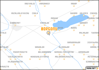
Börgönd (Fejér, Hungary)Börgönd is a town in the Fejér region of Hungary. An overview map of the region around Börgönd is displayed below.
regional and 3d topo map of Börgönd, Hungary ::
Börgönd airports ::
The nearest airport is BUD - Budapest Ferihegy, located 62.3 km north east of Börgönd.
Other airports nearby include BTS - Bratislava M R Stefanik (149.3 km north west), SLD - Sliac (169.6 km north), PZY - Piestany (170.5 km north), VIE - Vienna Schwechat (181.0 km north west), Nearby towns ::
Kisfalud (3.9km north) //
Dinnyés (3.1km north east) //
Belsőhegy (5.7km north) //
Belmajor (5.7km north) //
Pákozd (5.7km north) //
Páskum (5.7km north) //
Sashalom (6.1km south west) //
Belsőbáránd (7.5km south) //
Elzamajor (6.7km south east) //
Selymespuszta (7.8km south) //
Csala (8.3km north west) //
Seregélyes (8.3km south east) //
Seregélyesi Tanyák (8.3km south east) //
[all distances 'as the bird flies' and approximate]  Places with similar names to Börgönd, Hungary ::
// Burkuntē (ET)
// Bergante (PH)
// Borgunto (IT)
// Brugneto (IT)
// Bergüenda (ES)
// Burgunda (RU)
// Burgunda (RU)
// Bāraikānda (BD)
// Barai Kāndi (BD)
// Baraikāndi (BD)
Disclaimer :: Information on this page comes without warranty of any kind |
||
|
Where is Börgönd? Elevation and coordinates ::
Latitude (lat): 47°10'0"N Longitude (lon): 18°32'0"E
Elevation (approx.): 102m (map arrows pan, magnifying glasses zoom) |
||
|
Visiting Börgönd? Hotel/Accommodation ::
Book a hotel in Börgönd Travel Guide ::
Buy a travel guide for Hungary rental cars ::
car rental offers GPS waypoint ::
download a GPX waypoint (PoI) of Börgönd for your GPS receiver
|
||