|
search place name
|
||
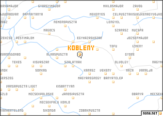
Köblény (Baranya, Hungary)Köblény is a town in the Baranya region of Hungary. An overview map of the region around Köblény is displayed below.
regional and 3d topo map of Köblény, Hungary ::
Köblény airports ::
The nearest airport is OSI - Osijek, located 101.1 km south east of Köblény.
Other airports nearby include BUD - Budapest Ferihegy (145.9 km north east), BTS - Bratislava M R Stefanik (223.6 km north), VIE - Vienna Schwechat (240.2 km north west), Nearby towns ::
Szalatnak (2.3km south west) //
Kárász (3.9km south) //
Istvándimajor (3.2km south west) //
Hegyhátmaróc (3.2km north east) //
Egyházaskozár (3.9km north) //
Bikal (3.9km north) //
Almáspuszta (3.8km west) //
Magyaregregy (5.7km south) //
Keresztestanya (4.3km north west) //
Alsómocsolád (4.3km north west) //
Vékény (5.3km south east) //
Tófů (5.4km east) //
Szászvár (6.3km south east) //
Kisbattyán (7.8km south) //
Nemerőpuszta (7.8km north) //
Bányatelep (7.6km south east) //
Mágocs (7.6km north west) //
Lengyel (9.0km north east) //
[all distances 'as the bird flies' and approximate]  Places with similar names to Köblény, Hungary ::
Disclaimer :: Information on this page comes without warranty of any kind |
||
|
Where is Köblény? Elevation and coordinates ::
Latitude (lat): 46°18'0"N Longitude (lon): 18°18'0"E
Elevation (approx.): 209m (map arrows pan, magnifying glasses zoom) |
||
|
Visiting Köblény? Hotel/Accommodation ::
Book a hotel in Köblény Travel Guide ::
Buy a travel guide for Hungary rental cars ::
car rental offers GPS waypoint ::
download a GPX waypoint (PoI) of Köblény for your GPS receiver
|
||