|
search place name
|
||
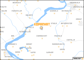
Kopárhát (Baranya, Hungary)Kopárhát is a town in the Baranya region of Hungary. An overview map of the region around Kopárhát is displayed below.
regional and 3d topo map of Kopárhát, Hungary ::
Kopárhát airports ::
The nearest airport is OSI - Osijek, located 69.0 km south of Kopárhát.
Other airports nearby include BUD - Budapest Ferihegy (153.9 km north), BEG - Beograd (181.9 km south east), Nearby towns ::
Csanádikert (3.7km south) //
Nagyszigetdůlő (3.2km north east) //
Kutaspuszta (3.2km north east) //
Dunafalva (3.9km west) //
Józsefmajor (3.9km west) //
Ágaserdő (3.9km west) //
Leneskert (3.9km west) //
Papkerterdő (3.9km west) //
Újistálló (3.9km west) //
Gálhegy (5.1km west) //
Dunaszekcső (5.1km west) //
Alsószállás (5.5km west) //
Báta (6.8km north west) //
Malomfa (6.8km north west) //
Kiserdőtanyák (6.3km south east) //
Nagybaracska (6.3km south east) //
Piszkula (6.3km south east) //
Ilimány (6.3km south east) //
Sárhát (8.4km south west) //
Szeremle (8.4km north east) //
Élesd (9.0km south west) //
Püspökpuszta (9.0km south east) //
[all distances 'as the bird flies' and approximate] 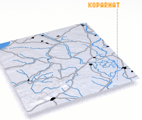 Places with similar names to Kopárhát, Hungary :: Disclaimer :: Information on this page comes without warranty of any kind |
||
|
Where is Kopárhát? Elevation and coordinates ::
Latitude (lat): 46°5'0"N Longitude (lon): 18°50'0"E
Elevation (approx.): 83m (map arrows pan, magnifying glasses zoom) |
||
|
Visiting Kopárhát? Hotel/Accommodation ::
Book a hotel in Kopárhát Travel Guide ::
Buy a travel guide for Hungary rental cars ::
car rental offers GPS waypoint ::
download a GPX waypoint (PoI) of Kopárhát for your GPS receiver
|
||